Visual Materials
South America agreeable to the most approved Maps and Charts, by Mr. Kitchen
You might also be interested in
Image not available
South America agreeable to the most approv'd Maps and Charts, by T. Kitchin, Geogr. Hydrographer to his Majesty
Visual Materials
See 093:630 for map from same plate, with variations. Cartouche: Native with tent.. Prime meridian: London, Ferro. Relief: pictorial. Graphic Scale: Miles, leagues. Projection: Pseudocylindrical. Printing Process: Copper engraving. Other Features: Cartouche. Verso Text: MS note: 620.
093:620 M
Image not available
An Accurate Map of South America, from the best Modern Maps and Charts. By Thos. Bowen, Geog
Visual Materials
Kashnor dates as ca. 1790. Prime meridian: London. Relief: pictorial. Graphic Scale: Miles, leagues. Projection: Pseudocylindrical. Printing Process: Copper engraving. Verso Text: MS note: 833.
105:833 S
Image not available
South America From the latest Discoveries, Shewing the Spanish & Portuguese Settlements according to Mr. D'Anville, by De Larochette
Visual Materials
Cartouche: ribboned w. coins & arrows.. Prime meridian: Ferro. Relief: pictorial. Graphic Scale: Miles, leagues, paces. Projection: Pseudocylindrical. Watermark: Crowned fleur-di-lis, IHS over Ivilledary. Printing Process: Copper engraving. Other Features: Cartouche. Verso Text: MS notes: 98 105/861.
105:861 M
Image not available
South America Corrected from the Observations communicated to the Royal Societys of London & Paris. By John Senex, at the Globe against St. Dunstans Church Fleet Street
Visual Materials
See 105:858. Kashnor dates as ca. 1710. Cartouche: Indian maiden and cannibals.. Prime meridian: London. Relief: pictorial. Graphic Scale: Miles, leagues. Projection: Pseudocylindrical. Printing Process: Copper engraving. Other Features: Cartouche. Verso Text: MS note: 623.
093:623 M
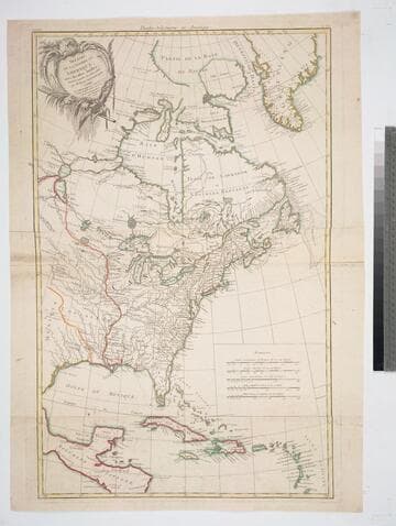
Théatre de la Guerre en Amerique, avec les Isles Antilles
Visual Materials
Kashnor notes, " A very scarce War Map." Prime meridian: Paris. Relief: pictorial. Graphic Scale: Miles, leagues. Projection: Pseudocylindrical. Printing Process: Copper engraving. Other Features: Cartouche. Verso Text: MS note: 147.
105:147 M
Image not available
A new and compleat map of all America : also of the West India & other islands depending thereon ; with a copious table fully shewing the several possessions of each European prince & state ; as settled by the definitive treaty concluded at Paris Febr. 10th, 1763, the clauses of which relative thereto are inserted / by John Gibson, Geographer
Rare Books
A large map in two sheets. Submap: Baffins & Hudsons Bay Cartouche: Trees and animals. Prime meridian: Ferro. Relief: pictorial. Graphic Scale: Miles, leagues. Projection: Pseudocylindrical. Printing Process: Copper engraving.
480573