Manuscripts
Rancho de Santa Gertrudes according to survey of J.E. Terrell

You might also be interested in

Sn. Gertrudes
Manuscripts
Bordered by Ranchos Los Cierritos [sic], Coyotes. Showing township & section numbers, stations, posts; table of boundary data. Alt title supplied by cataloger.
mssSolano SR_Box_25(07).02

Plat of the Rancho Sausal Redondo
Manuscripts
Bordered by Pacific Ocean, Ranchos San Pedro, La Ballona and public lands Within stapled document, "Rancho Sausal Redondo Patent," p.17; approved & verified in 1875; showing township & lot numbers, courses, distances, posts, surface detailing; table of boundary data. Alt. title supplied by cataloger.
mssSolano SR_Box_25(10).01
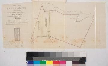
Rancho Santa Anita. ; owned by J.A. Rowe
Manuscripts
Second to last page of document, "Rancho Santa Anita, Triangular tract of Griffin and Wilson..." Showing parcel owners, acreage, courses, distances, surface details, township numbers ; color highlighting ; table of stations, courses, chains. Alt. title supplied by cataloger.
mssSolano SR_Box_25(06).04

Rancho Santa Gertrudes - Pettis Tract
Manuscripts
Within bound document, "Rancho San Gertrudis, Pettis tract..." p.3; showing lot numbers, acreage, lot owners, courses, distances; Subdivided by G.M. Baldwin. Title supplied by cataloger.
mssSolano SR_Box_25(07).06

Plat of the Rancho Los Alamitos finally confirmed to A. Stearns
Manuscripts
Bordered by Los Cerritos Rancho, Pacific Ocean, Rancho Bolsa Chica, Ranchos Los Bolsas, Rancho Los Coyotes. Surveyed under the Instructions from the U.S. Surveyor General. Approved 1860 & 1861 by J.W. Mandeville (?) and L. Upson, 1867, U.S. Surveyor Generals Cal.. Colored highlights around boundaries. Includes two bays and numerous sloughs. Boundary landmarks. T. IV S.R. XII W, T IV S.R. XI W., T V S.R. XIII W., T.V S.R. XI W., T V S.R. XII W.. Inset with table of boundary coordinates and distances
mssSolano SR_Map_0006

Rancho Los Alamitos owned by Don Abel Stearns
Manuscripts
Bordered by the Pacific Ocean, Rancho Los Sierritos [Cerritos], Rancho Bolsa Chica,. Rancho Los Coyotes. [Map must be after February 23, 1857 when district court affirmed the claim.]. Inset of table listing distances. Magnetic Meridian Var. 13° 30' east. T. 4 S.R. 11 W.. T. 5 S.R. 11 W.. T. 4 S.R. 12 W.. Color highlights. Includes wetlands and waterways, hachures. Originally granted to Don Juan Jose Nieto by Governor Jose Figueroa 1833
mssSolano SR_Map_0005