Manuscripts
Map of the Agricultural land of Rancho San Gertrudis

You might also be interested in
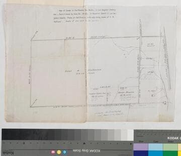
Map of the Lands in the Rancho San Pedro
Manuscripts
...Partitioned in Case No. 15,697 [within document]; shows courses, distances, acreage, parcel owners, lot numbers, markers. Alt. title supplied by cataloger.
mssSolano SR_Box_23(14).01
Map of the Colima Tract
Manuscripts
Showing section numbers, acreage, courses, distances; parcel owners (list with corresponding acreage), structures, surface details, markers. Alt title supplied by cataloger.
mssSolano SR_Box_25(07).01

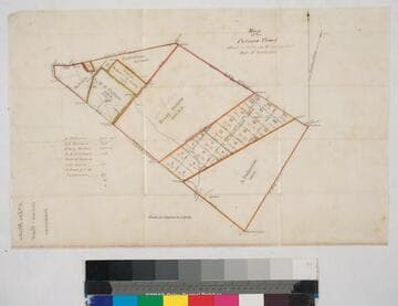
Map of the land of A.B. Chapman
Manuscripts
Last page of bound document, "Land of A.B. Chapman in the Ro. Sta. Anita, subdivided for taxation..." showing courses, distances, parcel owners, lots numbers, acreage. Alt. title supplied by cataloger.
mssSolano SR_Box_25(06).10
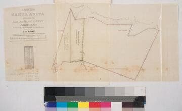
Rancho Santa Anita. ; owned by J.A. Rowe
Manuscripts
Second to last page of document, "Rancho Santa Anita, Triangular tract of Griffin and Wilson..." Showing parcel owners, acreage, courses, distances, surface details, township numbers ; color highlighting ; table of stations, courses, chains. Alt. title supplied by cataloger.
mssSolano SR_Box_25(06).04
Rancho San Antonio : S65 - subdivision map, land between Los Angeles and Old San Gabriel rivers
Manuscripts
With color highlighting, surface details; courses, distances, showing parcel numbers and acreage, parcel owners. Title supplied by cataloger.
mssSolano SR_Box_23(06).03

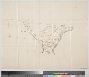
Plat of the Santa Anita Rancho finally confirmed to Henry Dalton
Manuscripts
Sierra Madre or San Gabriel Mtns Color highlighting ; featuring parcel owners, township & section numbers, stations, courses, distances, acreage, with two tables of boundary data ; minor surface detail. Alt. title supplied by cataloger.
mssSolano SR_Box_25(06).01