Manuscripts
Map of Rancho Santa Anita

You might also be interested in

Plat of the Santa Anita Rancho finally confirmed to Henry Dalton
Manuscripts
Sierra Madre or San Gabriel Mtns Color highlighting ; featuring parcel owners, township & section numbers, stations, courses, distances, acreage, with two tables of boundary data ; minor surface detail. Alt. title supplied by cataloger.
mssSolano SR_Box_25(06).01

Map of the Rancho Tujunga
Manuscripts
Featuring vegetation, hachures, structures, High Ridge of Mountains, crops/fields; courses, distances, stations, boundary markers, section & township numbers. Alt. title supplied by cataloger.
mssSolano SR_Box_25(14).01

Map of a Tract of Land
Manuscripts
La Puente, Los Coyotes. Color highlighting, surface details, couses, distances; vegetation, structures. Alt. title supplied by cataloger.
mssSolano SR_Box_22(15).05
Image not available
Plat of the Santa Anita Rancho finally confirmed to Henry Dalton
Manuscripts
Sierra Madre or San Gabriel Mtns. to the north Within document, "Rancho Santa Anita, Triangular tract of Wilson & Griffin..." 4 tables with boundary data ; courses, distances, stations ; township & section numbers ; surface details, color highlighting
mssSolano SR_Box_25(06).07
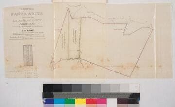
Rancho Santa Anita. ; owned by J.A. Rowe
Manuscripts
Second to last page of document, "Rancho Santa Anita, Triangular tract of Griffin and Wilson..." Showing parcel owners, acreage, courses, distances, surface details, township numbers ; color highlighting ; table of stations, courses, chains. Alt. title supplied by cataloger.
mssSolano SR_Box_25(06).04

Plat of the Rancho Paso de Bartolo finally confirmed to Pio Pico
Manuscripts
Bordered by Ranchos Santa Gertrudes, San Antonio, La Merced, Potrero de Felipe Lugo, La Puente and public lands. Shows section numbers, surface details, parcel owners, structures, markers, acreage; color highlighting; has table with boundary data. Alt. title supplied by cataloger.
mssSolano SR_Box_22(06).05