Manuscripts
Map made from the Tablings.; Rancho San Francisquito

You might also be interested in

Map made from the Tablings.; Rancho San Francisquito
Manuscripts
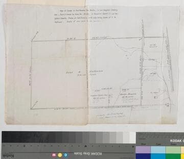
Variant of first map in this folder - 2 of 2 copies; P. 9 of fastened document, "Survey of the subdivision of the Rancho San Francisquito..." showing Dalton & Wheeler parcels, courses, distances, stations, markers. Alt. title supplied by cataloger.
mssSolano SR_Box_23(08).05B

Map made from the Tablings.; Rancho San Francisquito
Manuscripts
Variant of first map in this folder - 1 of 2 copies; f. 8 of fastened document, "Survey of the subdivision of the Rancho San Francisquito..." showing Dalton & Wheeler parcels, courses, distances, stations, markers. Alt. title supplied by cataloger.
mssSolano SR_Box_23(08).05A
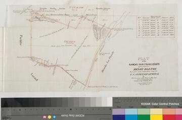
Plat of the Rancho San Francisquito
Manuscripts
Bordered by public lands, Rancho s La Puente, Azuza [sic], Santa Anita, Potrero de Felipe Lugo. p. 6 of fastened document, "Patent of the Ro. San Francisquito," featuring T1s R11W Lot No. 43, showing roads from San Gabriel to Azuza, to San Jose, from El Monte to Azuza; surface details, takes & other markers; courses, distances (with corresponding table), San Gabriel River. Alt. title supplied by cataloger.
mssSolano SR_Box_23(08).03
Image not available
Rancho San Francisquito: S63 - sketch maps
Manuscripts
Pgs. 3-5 of fastened document, "Survey of the subdivision of the Rancho San Francisquito..." showing courses, distances; also a sketch on blue lined paper with calculations following survey tabling re: Puente Road. Title supplied by cataloger.
mssSolano SR_Box_23(08)
Map of the Lands in the Rancho San Pedro
Manuscripts
...Partitioned in Case No. 15,697 [within document]; shows courses, distances, acreage, parcel owners, lot numbers, markers. Alt. title supplied by cataloger.
mssSolano SR_Box_23(14).01