Manuscripts
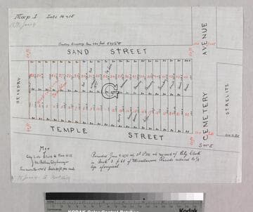
Map of City Lots Block G Fort Hill: Map 1, Lots 14 & 15

You might also be interested in
Map of City Lots Block G Fort Hill: Map 1, Lots 14 & 15
Manuscripts
Sand to Temple St., west from Cemetery Ave., with lot owners; red, black ink with color highlighting. . Alt title supplied by cataloger.
mssSolano SR_Map_0446.01

Block & Fort Hill Tract
Manuscripts
Castelar to Buena Vista St., Bellevue Ave. (Short St.) to Sand St., showing structures, lot owners, with notes; courses, distances, survey history. Paper watermark: Southworth’s 1882 Linen Bank. Alt title supplied by cataloger.
mssSolano SR_Map_0737

Map of Lots 1-7 in the Junction Block
Manuscripts
San Fernando St. to Downey Ave. from their junction to Aurora St., showing structures, lot owners; red, blue, black inks; courses, distances, hachures; shows subdivision of Hellman, Haas & Co.. Originally surveyed by L. Seebold. Paper watermark: Royal Linen Ledger. Alt title supplied by cataloger.
mssSolano SR_Map_0707

Partition Map of lots 14, 15, 16, 19 and 20 of the Childs Tract
Manuscripts
...showing division made by the owners; showing lot numbers, courses, distances Grand Avenue, waterways (red & black ink, pencil notations). Alt. title supplied by cataloger.
mssSolano SR_Box_27(14).07

Lots in the Fort Hill Tract
Manuscripts
Buena Vista to Philadelphia St. from Sand and Temple St. to Canal & Reservoir and Short St.; includes cemetery, F & A.M., I.O.O.F.; adjacent tracts: Bunker Hill, Pavilion. Alt title supplied by cataloger.
mssSolano SR_Map_0625

Map of the Eaton Lots on the N.W. side of New High Street
Manuscripts
New High to Buena Vista St., north from Temple St., showing structures, lot owners [no one named Eaton]. Red & black ink with color highlights; bearings & distances. Alt title supplied by cataloger.
mssSolano SR_Map_0448