Visual Materials
West Indies

You might also be interested in

The West Indies According to the best Authorities
Visual Materials
Kashnor notes: "Includes the coast of present-day Texas, New Leon, Louisiana and Florida." "Engraved for Guthries new System of Geography." Prime meridian: London, Ferro. Relief: pictorial & hachures. Graphic Scale: Miles, leagues. Projection: Cylindrical. Printing Process: Copper engraving. Verso Text: MS note: 802.
105:802 S

A New Map of the West India Isles, from the Latest Authorities, By John Cary, Engraver. 1803
Visual Materials
Kashnor notes, "Shows the coast of present-day Texas, Florida, North and South Carolinas." Prime meridian: GM. Relief: hachures. Projection: Cylindrical. Printing Process: Engraving. Verso Text: MS notes: 801 56.
105:801 M

West Indies
Visual Materials
Kashnor notes, "A valuable map, showing Texas and the Colony of New Santander, and locates El Paso in New Mexico." Kashnor shows [Carey, 1818]. Prime meridian: GM. Relief: hachures. Projection: Cylindrical. Printing Process: Copper engraving. Verso Text: MS note: 803.
105:803 S
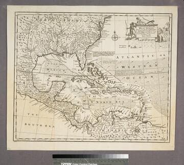
An Accurate Map of the West Indies
Visual Materials
Kashnor notes, "Includes Florida, Georgia, Carolina, Virginia, and Maryland. Also shows the coast of New Leon and present-day Texas." Kashnor dates as ca. 1767. RLIN record suggests 1747. Cartouche: Natives & Lion.. "Drawn from the best Authorities, assisted by the most approved Modern Maps and Charts, and regulated by Astronomical Observations. By Eman. Bowen." Prime meridian: London. Relief: pictorial. Graphic Scale: Miles. Projection: Azimuthal. Printing Process: Copper engraving. Other Features: Cartouche. Verso Text: MS note:943.
105:943 S

Insulae Americanae Nempe: Cuba, Hispaniola, Jamaica, Pto. Rico, Lucania, Antillae vulgo Caribae, Barlo-et sotto-vento, Etc
Visual Materials
Kashnor notes, "A rare map showing parts of Florida and "Florida Gallica", now Georgia. It also shows the coast of present-day Texas, with the old Spanish locations." Alt. title in upper margin. Prime meridian: Ferro. Relief: pictorial. Graphic Scale: Miles. Projection: Mercator. Printing Process: Copper engraving. Verso Text: MS note: 798.
105:798 M
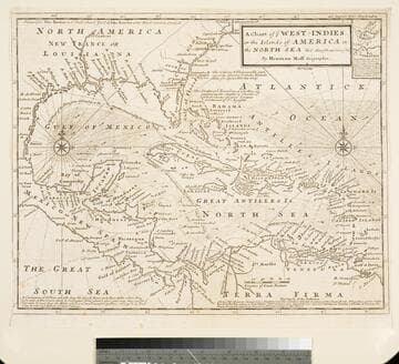
Chart of the West Indies or the Islands of America in the North Sea &c. Being the Present Seat of War. by Herman Moll Geographer
Visual Materials
Kashnor notes, "Shows the mainland around the Gulf of Mexico, with Louisiana, Florida, Georgia, and Carolina." Kashnor dates as ca. 1719. Submap: Vera Cruz harbor. Sailing instructions for galleons. MS note: 321 (on backing). Prime meridian: London. Relief: no. Projection: Cylindrical. Watermark: Two devices. Printing Process: Copper engraving. Other Features: Sub-maps.
105:321 S