Manuscripts
Ranchos Topanga Malibu Sequit, Boca de Santa Monica, and San Vicente y Santa Monica

You might also be interested in

Ranchos Topanga Malibu Sequit, Boca de Santa Monica, and San Vicente y Santa Monica
Manuscripts
Bordered by Pacific Ocean, ranchos El Conejo, Las Virgenes, San Jose de Buenos Ayres. . Public lands in T.1S. R.16-19W. S.B.M.. Numbered sections with rivers, ports, town of Santa Monica, railroad. . Title supplied by cataloger.
mssSolano SR_Map_0269.01

Map of Survey of the Rancho Rincon de los Bueyes
Manuscripts
Bordered by public lands, Ranchos Ballona, Las Cienegas, Cienega ó Paso de la Tijera, San Jose de buenos Ayres, Rodeo de las Aguas. Incomplete copy of previous map, less detail and notation; slightly different title. Structures and surface detail.
mssSolano SR_Map_0129.02
Image not available
[ranchos Topanga Malibu Sequit, Boca de Santa Monica, and San Vicente y Santa Monica, with public lands in T.1S. R. 16-19W. S.B.M.]
Manuscripts
The collection consists of maps, field books, legal documents, business papers, and diaries related to the work of surveyors George Hansen, Alfred Solano, Sidney B. Reeve, and others. The maps and surveys in the collection are of the city of Los Angeles, Southern California ranchos, and subdivisions of the city of Los Angeles and neighboring towns. The collection contains over maps and sketch maps. Other subjects represented in the collection include: civil engineering, land subdivision, mines and mineral resources, and daily life in Los Angeles and Los Angeles County.
mssSolano
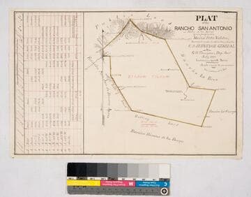
Plat of the Rancho San Antonio or Rodeo de las Aguas
Manuscripts
Bordered by Ranchos La Brea, San Jose de Buenos Ayres, Rincon de los Bueyes, La Cienega and public land. Hachures, land features, structures. Finally confirmed to Maria Rita Valdez. Table inset with courses, distances, acres.
mssSolano SR_Map_0132

Map of the Rincon de los Bueyes
Manuscripts
Bordered by public lands, Ranchos Ballona, Las Cienegas, Cienega ó Paso de la Tijera, San Jose de buenos Ayres, Rodeo de las Aguas. Surveyed by order of the commissioners . . . district court . . . filed October 12th 1875 (with signatures). Structures and surface detail: dense hachures; roadways, Ballona creek, parcel owners indicated.
mssSolano SR_Map_0129.01
Image not available
H.W. Keller, Santa Monica [Rancho Topanga Malibu Sequit];
Manuscripts
The collection consists of maps, field books, legal documents, business papers, and diaries related to the work of surveyors George Hansen, Alfred Solano, Sidney B. Reeve, and others. The maps and surveys in the collection are of the city of Los Angeles, Southern California ranchos, and subdivisions of the city of Los Angeles and neighboring towns. The collection contains over maps and sketch maps. Other subjects represented in the collection include: civil engineering, land subdivision, mines and mineral resources, and daily life in Los Angeles and Los Angeles County.
mssSolano