Manuscripts
Map of the 25 acre tract

You might also be interested in

Map of the Keller Tract
Manuscripts
...in the North East quarter of Sec. 16, T.2 S.R.13 W. S.B.M., South Ave. to Alameda St. from Vernon Ave. to Rubio St., showing parcel owners, color highlighting, courses, distances, acreage; pencil calculations. Paper watermark: Royal Linen Ledger. Alt title supplied by cataloger.
mssSolano SR_Map_0690

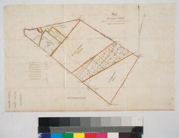
Mooney - tracts south of Jefferson & Figueroa & Main sts
Manuscripts
P. 4 of fastened document, "Graf - refer to survey March 14, 1874... Calculation of fractions..." showing courses, distances, acreage, structures, southern boundary of pueblo lands of LA city; NE 1/4 Sec. 7 T2S R13W, NW 1/4 Sec. 8 T2S R13W. Title supplied by cataloger.
mssSolano SR_Box_30(19).03

Howland, William R. - parcel
Manuscripts
P. 4 of document, "Survey of E. 1/2 of N.W. 1/4 of Sec. 31..." T2S R13W sections 30-31 showing parcel owners, courses, distances, acreage. Title supplied by cataloger.
mssSolano SR_Box_28(59).01

Acres.; south of the City of Los Angeles
Manuscripts
...in sec. 8-9,16-17 with green highlighting; acreage, courses, distances, parcel owners. Alt. title supplied by cataloger.
mssSolano SR_Box_26(16).01
Map of the Colima Tract
Manuscripts
Showing section numbers, acreage, courses, distances; parcel owners (list with corresponding acreage), structures, surface details, markers. Alt title supplied by cataloger.
mssSolano SR_Box_25(07).01

Tract of vacant land containing 3.91 acres
Manuscripts
Dense hachures, zanjas, LA River; city lands; other parcel owners: R. Cararajaz [?], L. [?] Willhard; courses, distances, acreage. Alt. title supplied by cataloger.
mssSolano SR_Box_29(05).01