Opening Hours
Daily: 10 A.M.–5 P.M.
Closed on Tuesdays
1151 Oxford Road
San Marino, CA 91108
Daily: 10 A.M.–5 P.M.
Closed on Tuesdays
1151 Oxford Road
San Marino, CA 91108

Image not available
Visual Materials
Kashnor dates [1759]. Submap locates forces. MS note: 680 (on backing). Submap: Troop deployment on the Plain of Abraham.. Relief: hachures. Graphic Scale: Miles. Projection: Plane. Printing Process: Copper engraving.
105:680 S
Image not available
Visual Materials
Kashnor notes, "A scarce map showing the movements of vessels and troops." Submap: Plan of the Action gained by the English near Quebec, Sep. 13. 1759. MS note: 341 (on backing). Relief: hachures. Graphic Scale: Miles. Projection: Plane. Printing Process: Copper engraving. Other Features: Sub-maps. Verso Text: MS note: 341 (on backing).
093:341 S
Image not available
Visual Materials
This map appears to be a reduced size copy of Jefferys' map, 093:325 and 093:325A, 093:326. This map may have been the precursor for Jefferys' map, Jefferys notes on the upper right submap "Brought from there by an Officer of Distinction". Note position of map name and defense information is reversed on Jeffery's maps, but details are identical. Kashnor dates as [1760]. "under the Command of Vice-Adml. Saunders & Major Genl. Wolfe. down to the 5 Sepr.1759. Drawn by a Captain in his Majesties Navy." MS note: 674 (on backing) Submaps: Part of the Upper St. Lawrence River; A view of the action gain'd by the English Sepr. 13. 1759 near Quebec.. Relief: hachures. Graphic Scale: Miles. Projection: Plane. Printing Process: Copper engraving. Other Features: Sub-maps. Verso Text: MS note: S40 LT, other erased notes..
105:674 S
Visual Materials
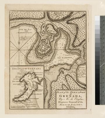
Kashnor dates as ca. 1760. Jolly notes publication date as December 1762. Submap of island. Submap: The Isle of Grenada. MS note: 404 (on backing). Relief: hachures. Graphic Scale: Fathoms. Projection: Plane. Printing Process: Copper engraving. References: Jolly, Brit. Periodicals LOND - 219.
105:404 S
Visual Materials
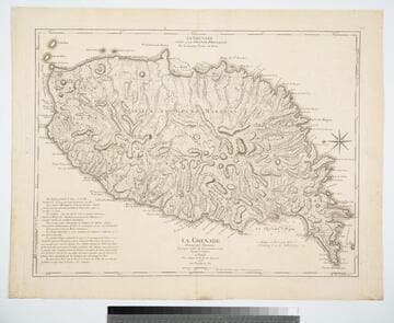
Kashnor notes, "The second issue, noting that D';Estaing attacked Port Royal in 1779." Prime meridian: Ferro, London. Relief: hachures. Graphic Scale: Leagues. Projection: Plane. Watermark: Chained maltese cross lettering. Printing Process: Copper engraving. Verso Text: MS note: 402.
105:402 M
Image not available
Visual Materials
Kashnor notes, "A plan of Phipps attack upon Quebec in 1690, with references to locations in the city,and to the 34 English vessels which comprised the expedition, with the 42 boats which made the landing." "Ville de l'Amerique Septentrionale dans la Nouvelle France avec Titre d'Eveché. Située sur le Fleuve de St. Laurent a 310 degrez 17. minutes de Longitude et 46 degr. 55. minutes de Latitude elle sur assiegée par les Anglios sur le Francois par qui elle est encore possedée l'an 1670 depuis le 16e. Octobre Jusqu'a 22 dev meme mois. Monsr. de Frontenac estant pour lors Gouverneur du Pays qui leur fit honteusement lever le Siege." See 105:770 for an apparently earlier version of this map. MS note: 769 (on backing). Relief: hachures. Projection: Plane. Printing Process: Copper engraving. Verso Text: MS note: 769.
105:769 S