Manuscripts
Potrero Chico

You might also be interested in

Plat of the Rancho Paso de Bartolo finally confirmed to Pio Pico
Manuscripts
Bordered by Ranchos Santa Gertrudes, San Antonio, La Merced, Potrero de Felipe Lugo, La Puente and public lands. Shows section numbers, surface details, parcel owners, structures, markers, acreage; color highlighting; has table with boundary data. Alt. title supplied by cataloger.
mssSolano SR_Box_22(06).05

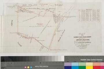
Rancho San Francisquito: T.1S. R.11W. S.B.M., showing subdivision of public lands
Manuscripts
Bordered by Ranchos Santa Anita, Azusa, La Puente, Potrero de Felipe Lug, Potrero Grande, La Merced. Black & red ink; section numbers & acreage (?) indicated; San Gabriel River & few land features, boundary markers. Title supplied by cataloger.
mssSolano SR_Map_0146

Map showing the Jesurun & Broderick lands in the Rancho Paso de Bartolo
Manuscripts
Bordered by Ranchos San Antonio, La Merced, Potrero de Felipe Lugo, La Puente. Indicates rival boundaries between Rancho Paso de Bartolo and the ranchos la Puente, Potrero de Felipe Lugo and la Merced. Color highlights; Rio Hondo, New San Gabriel rivers, and landowners indicated. Based on surveys by Solano, Solano & Stevenson, Ellis & Rowan.
mssSolano SR_Map_0107
Plat of the Rancho San Francisquito
Manuscripts
Bordered by public lands, Rancho s La Puente, Azuza [sic], Santa Anita, Potrero de Felipe Lugo. p. 6 of fastened document, "Patent of the Ro. San Francisquito," featuring T1s R11W Lot No. 43, showing roads from San Gabriel to Azuza, to San Jose, from El Monte to Azuza; surface details, takes & other markers; courses, distances (with corresponding table), San Gabriel River. Alt. title supplied by cataloger.
mssSolano SR_Box_23(08).03

Map of that part of Rancho Paso de Bartolo. described in the conveyance by Pio Pico to B. Cohn
Manuscripts
Bordered by Ranchos San Antonio, La Merced, Potrero de Felipe Lugo, La Puente. Case No. 20613: Julius B. Cohn, et al. vs. Charles Prager, Jeserun, & Broderick. Extensive hachures, color highlighting, section, parcel numbers, acreage; extensive tables of allotments, with courses, distances, acreage. Shows West Whittier, San Gabriel River.
mssSolano SR_Map_0791

Subdivision of the Rancho Paso de Bartolo finally confirmed to Don Pio Pico
Manuscripts
Bordered by Ranchos La Merced, Potrero de Felipe Lugo, La Puente and public lands. Color highlighting; showing parcel owners, structures, topographic details, rivers [Rio Hondo, San Gabriel - not identified]; survey notes on left edge.
mssSolano SR_Map_0789