Manuscripts
Plat of the Rancho Los Nogales

You might also be interested in

Rancho la Puente : S72 Plat of the Rancho La Puente finally confirmed to Julian ; Workman & John Roland i.d., Rowland
Manuscripts
Bordered by Ranchos De Azusa, San Jose, Los Nogales, Rincon de la Brea, Cajon de San Juan, La Habra, San Bartolo, Potrero de Filipi Lugo, San Franciquito and public lands. Showing townships, section numbers, markers, surface details - hachures, San Jose Creek, La Puente Hills; color highlighting, certification; table of boundary data. Title supplied by cataloger.
mssSolano SR_Box_22(15).01

Plat of the Rancho Paso de Bartolo.; finally confirmed to Pio Pico and Juan Perez
Manuscripts
Bordered by Ranchos San Antonio, La Merced, La Puente, Santa Gertrudes; property of McFarland & Downey. Bound within document: "Field Notes and Map of the Rancho Paso de Bartolo..." (Hansen) Showing San Gabriel River, subdivided public lands, townships & section numbers, courses & distances, structures, surface details; with survey notes, table of boundaries, certification; colored inks. Alt. title supplied by cataloger.
mssSolano SR_Box_22(07).14
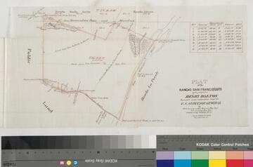
Plat of the Rancho San Francisquito
Manuscripts
Bordered by public lands, Rancho s La Puente, Azuza [sic], Santa Anita, Potrero de Felipe Lugo. p. 6 of fastened document, "Patent of the Ro. San Francisquito," featuring T1s R11W Lot No. 43, showing roads from San Gabriel to Azuza, to San Jose, from El Monte to Azuza; surface details, takes & other markers; courses, distances (with corresponding table), San Gabriel River. Alt. title supplied by cataloger.
mssSolano SR_Box_23(08).03

Plat of the Rancho Paso de Bartolo finally confirmed to Pio Pico
Manuscripts
Bordered by Ranchos Santa Gertrudes, San Antonio, La Merced, Potrero de Felipe Lugo, La Puente and public lands. Shows section numbers, surface details, parcel owners, structures, markers, acreage; color highlighting; has table with boundary data. Alt. title supplied by cataloger.
mssSolano SR_Box_22(06).05

Plat of the Ballona Rancho
Manuscripts
Vertification dated October 1863, and other notations; shows Inner Bay, Shoalwater Bay of the Pacific Ocean; township & lot numbers, stakes, surface details. Alt. title supplied by cataloger.
mssSolano SR_Box_25(10).03

Plat of the Rancho Sausal Redondo
Manuscripts
Bordered by Pacific Ocean, Ranchos San Pedro, La Ballona and public lands Within stapled document, "Rancho Sausal Redondo Patent," p.17; approved & verified in 1875; showing township & lot numbers, courses, distances, posts, surface detailing; table of boundary data. Alt. title supplied by cataloger.
mssSolano SR_Box_25(10).01