Manuscripts
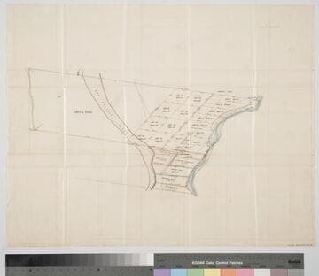
River San Gabriel in the Los Nietos Irrigation District

You might also be interested in

Property of J.G. Downey, L. Willhart, E. Moulton, M. Ruiz, Dolores Sepulveda and Benita Peraza and Julian Chavis
Manuscripts
East side of Los Angeles River from Arroyo Seco south to Block 61, Hancock's Survey, shows structures, detailed hachures, waterways, vegetation, parcel owners; color highlighting; courses & distances. Surveyed by William Moore, delineated by Frank Lecouvreur.. Alt title supplied by cataloger.
mssSolano SR_Map_0429

Map of that part of the Rancho San Pedro allotted to Manuel Dominguez
Manuscripts
Bordered by Pacific Ocean, Rancho Los Cerritos, Sausal Redondo. Showing parcel owners: heirs of Maria Engracia Cota de Dominguez. Surface detail: hachures, water bodies, vegetation, subdivisions; color highlighting. Numerous tables with partitioned tract data, courses, distances, owners; table of allotments, Inner Bay, Salt Flat, Rattlesnake Island courses, distances. Signed by witnesses.
mssSolano SR_Map_0797

Park Tract on the East side of Los Angeles river
Manuscripts
Showing the line of partition agreed on by Charles T. Park & Eugene D. Park, surveyed at their request; reference survey for B. Cohn July 10, 1871. Hachures, color highlighting; courses, distances, acreage, vegetation shown. Title supplied by cataloger.
mssSolano SR_Map_0529

Map of the 35-Acre Lots of the Los Angeles City Lands. East of Los Angeles River
Manuscripts
Shows Rancho San Antonio to the south. Showing surface detail, vegetation, structures, parcel owners, structures, color highlights; courses, distances, section numbers, street names penciled in.
mssSolano SR_Map_0374.01
Rancho San Antonio : S65 - subdivision map, land between Los Angeles and Old San Gabriel rivers
Manuscripts
With color highlighting, surface details; courses, distances, showing parcel numbers and acreage, parcel owners. Title supplied by cataloger.
mssSolano SR_Box_23(06).03

Rancho la Ballona : S87, partition of 1868
Manuscripts
Map is on verso of last page of document entitled, "1868 Ro. La Ballona, John D. Young, et al, vs. Ignacio Machado, et al..." Shows courses, distances, structures, including school house lot, house of G. Talamantes; color highlighting, hachures, waterways, vegetation, parcel owners. Title supplied by cataloger.
mssSolano SR_Box_20(07).15