Manuscripts
Map of the Consuelo & Brodrick subdivisions of the Celis Vineyard Tract

You might also be interested in

Consuelo subdivision of the Celis Vineyard Tract
Manuscripts
Pine to Celis St., Main St. to east of Carlisle St.; courses, distances, parcel numbers. Survey requested by F. de Celis. Pencil calculations, annotations. Alt title supplied by cataloger.
mssSolano SR_Map_0565.02

Consuelo subdivision of the Celis Vineyard Tract
Manuscripts
Pine to Celis St., Main St. to east of Carlisle St.; courses, distances, parcel numbers. Survey requested by F. de Celis. Pencil calculations, annotations which extend map slightly further north along Main. Alt title supplied by cataloger.
mssSolano SR_Map_0565.03

Los Angeles : draft of projected Consuelo subdivision
Manuscripts
Numbered lots along Main St. between Pine & Celis streets; Brodrick subdivision labeled, but detailed. Note on change of Consuelo subdivision as of December 1882. Title supplied by cataloger.
mssSolano SR_Map_0565.04

Consuelo subdivision of the Celis Vineyard Tract
Manuscripts
Pine to Celis St., Main St. to east of Carlisle St.; courses, distances, parcel numbers. Survey requested by F. de Celis. Alt title supplied by cataloger.
mssSolano SR_Map_0565.01
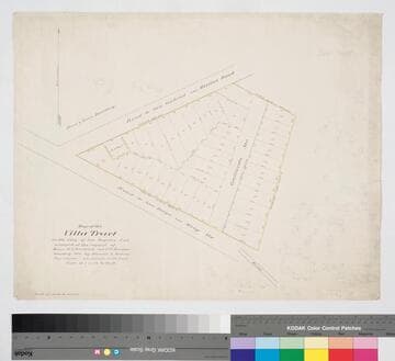
Villa Tract
Manuscripts
Macy St. and Mission Rd. to east of Gallardo St., Block 62, Hancock's Survey. Color highlighting; courses, distances, parcel numbers in red; pencil calculations. Surveyed at the request of W.J. Brodrick & T.E. Rowan. [paper watermarks: Southworth 1882 Linen Bank]. Alt title supplied by cataloger.
mssSolano SR_Map_0598

Supplemental Map of Newell & Rader Subdivision of the Celis Vineyard Tract
Manuscripts
Along Santee St. and Maple Ave. from Washington to Pine St.; sketch copied from LA County records; courses, distances, parcel numbers; also indicates Brodrick & Consuelo subdivisions. Paper watermark: Royal Linen Ledger. [see also Maps 406, 473, 476, 565, 647, 651, 700]. Alt title supplied by cataloger.
mssSolano SR_Map_0706