Manuscripts
Los Angeles : partial street plan

You might also be interested in

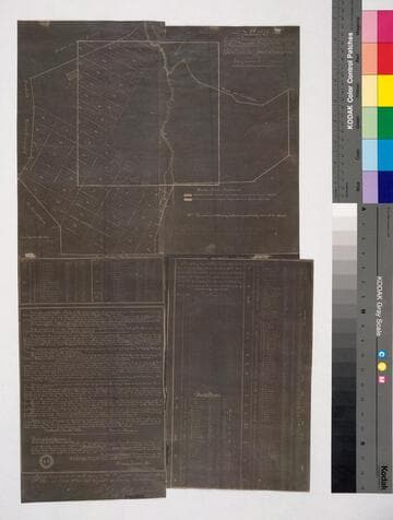
Map of the 35 Acre Tracts of the Los Angeles City Lands, Hancock's Survey, situate on the Southern Slope of the Stone Quarry Hills
Manuscripts
Southern Slope of the Stone Quarry Hills Blocks 41-43, 45-47, Hancock's Survey, dense hachures, structures, parcel owners; details of sell-off, public lands, road improvements. Shows Chaves & other ravines, Catholic cemetery, LA River. [See also Map 378 - based on same survey].
mssSolano SR_Map_0377

Map of Grasshopper Street from 6th St. to Pio Pico St
Manuscripts
and the Extension of Seventh Street from Grasshopper Str. to the City Limits. Blocks 24, 25, 36, 37, Hancock's Survey, with topographical details; hachures; numbered parcels & owners. Alt title supplied by cataloger.
mssSolano SR_Map_0381

Los Angeles : Ward to Ninth Street from Pearl Street to City limits
Manuscripts
Blocks 25, 37, and parts of 24 and 36, Hancock's Survey, showing parcel owners & acreage. Title supplied by cataloger.
mssSolano SR_Map_0594
Image not available
Hancock, H[enry]
Manuscripts
Map showing the Donation Lots [negative photoprint of Hancock's Survey, both within confirmed City Limits and in Pueblo Lands, with relationship to ranchos los Felis, las Ciénegas, San Antonio, and Rosa de Castilla, including explanatory text and names of lot owners]
mssSolano
Map showing the Donation Lots
Manuscripts
Hancock's Survey [1857 August], within confirmed City Limits and in Pueblo Lands, with relationship to ranchos los Felis, las Ciénegas, San Antonio, and Rosa de Castilla, with explanatory text, lot owners. Alt title supplied by cataloger.
mssSolano SR_Map_0334

Los Angeles : northwest of Soto Street and Louisiana Ave
Manuscripts
Includes Block 60, parts of Blocks 59, 61-63, Hancock's Survey; bearings & distances. Notations re: Lopez, dated Jan' 30, 1872. Title supplied by cataloger.
mssSolano SR_Map_0407