Manuscripts
Map of partition of Ro. San Pedro

You might also be interested in

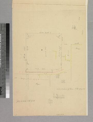
Map of a Part of the San Pedro Ranch
Manuscripts
Bordered to the north by Downey Beaudry & Hayward Tract, to the south by M. Dominguez [verso #35.] I. W. Hellman vs. J. G. Downey et al., tract, showing surface detail and parcel owners Property owners include Merchants Exchange Bank of S.F. Hachures, water bodies, borders indicated Verso: No. 939 I. W. Hellman vs. J. G. Downey et al. Oct 1881.
mssSolano SR_Map_0209.01

Map of a Part of the San Pedro Ranch
Manuscripts
Bordered to the north by Downey Beaudry & Hayward Tract, to the south by M. Dominguez. [verso #36] I. W. Hellman vs. J. G. Downey et al., tract, showing surface detail and parcel owners. Property owners include Merchants Exchange Bank of S.F. Hachures, water bodies, borders indicated. ; Alternate title supplied by cataloger.
mssSolano SR_Map_0209.02
Rancho San Pedro : S35 no. 2 - sketch map
Manuscripts
P. 13 of document: "Rancho San Pedro, Manuel Dominguez, Dominguez Heirs partition 1884/85... Dominguez Colony" showing courses, distances; minor color highlighting, parcel owners; acreage. Title supplied by cataloger.
mssSolano SR_Box_24(01).09

Rancho La Sierra (Yorba); S43 - partition map
Manuscripts
Bound volume: Rancho La Sierra, Partition 1876-1877. Showing acreage, courses, distances, parcel owners, surface detail; calculations; minor color. Title supplied by cataloger.
mssSolano SR_Box_25(11).20

Rancho La Sierra (Yorba) S43 : sketch maps
Manuscripts
Bound volume: Rancho La Sierra, Partition 1876-1877. Verso & recto of same sheet, showing courses, distances; parcel owners; color on verso map; . Title supplied by cataloger.
mssSolano SR_Box_25(11).21B

Rancho La Sierra (Yorba); S43 - sketch maps
Manuscripts
Bound volume: Rancho La Sierra, Partition 1876-1877. Verso & recto of same sheet, showing courses, distances; parcel owners; color on verso map; . Title supplied by cataloger.
mssSolano SR_Box_25(11).21A