Manuscripts
Map of the compromised dividing line between the Rancho Paso de Bartolo on the south side and the Ranchos La Puente, Potrero de Felipe Lugo and La Merced on the north side agreed upon by C. Prager et als owners of the Rancho Paso de Bartolo and H. A. Unruh for E.J. Baldwin owner of the Ranchos La Puente, Potrero de Felipe Lugo and La Merced

You might also be interested in
Image not available
[disputed boundary... Paso de Bartolo/la Puente/la Merced/Potrero de Felipe Lugo]
Manuscripts
The collection consists of maps, field books, legal documents, business papers, and diaries related to the work of surveyors George Hansen, Alfred Solano, Sidney B. Reeve, and others. The maps and surveys in the collection are of the city of Los Angeles, Southern California ranchos, and subdivisions of the city of Los Angeles and neighboring towns. The collection contains over maps and sketch maps. Other subjects represented in the collection include: civil engineering, land subdivision, mines and mineral resources, and daily life in Los Angeles and Los Angeles County.
mssSolano
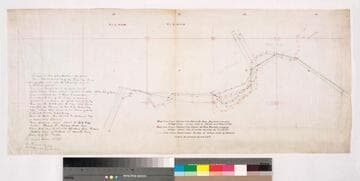
Disputed boundary : Paso de Bartolo, La Puente, La Merced, Potrero de Felipe Lugo
Manuscripts
Blue line indicates 1891 survey by Hansen & Solano, Red line indicates survey by T. J. Ellis, Green indicates gov't survey by Seebold. C. Prager (Paso de Bartolo) & H.A. Unruh for E. J. Baldwin (La Puente, Potrero de Felipe Lugo & La Merced) referenced. Title Supplied by cataloger.
mssSolano SR_Map_0104
Image not available
Rancho Potrero de Felipe Lugo
Manuscripts
The collection consists of maps, field books, legal documents, business papers, and diaries related to the work of surveyors George Hansen, Alfred Solano, Sidney B. Reeve, and others. The maps and surveys in the collection are of the city of Los Angeles, Southern California ranchos, and subdivisions of the city of Los Angeles and neighboring towns. The collection contains over maps and sketch maps. Other subjects represented in the collection include: civil engineering, land subdivision, mines and mineral resources, and daily life in Los Angeles and Los Angeles County.
mssSolano

Map of the Puente Creek and Springs in the Rancho Paso de Bartolo
Manuscripts
Bordered by Land of Cates. Drawn by Otto V. Ploennies from Seebold's notes dated November 24, 1873. New River San Gabriel, creeks & dams; hachures indicated; waterways in blue.
mssSolano SR_Map_0099

Paso Bartolo
Manuscripts
Rancho Santa Gertrudes. Few hachures, color highlights; Pico & Perez land indicated. Intersecting townships: T.II S. R.XII W., T.IS. R.XII W., T.IIS .R.XI W., T.IS. R. XI W.
mssSolano SR_Map_0095
Image not available
[boundaries of Rancho Potrero Grande, along with some boundaries of ranchos Potrero Chico, Potrero de Felipe Lugo, la Merced, & San Francisquito]
Manuscripts
The collection consists of maps, field books, legal documents, business papers, and diaries related to the work of surveyors George Hansen, Alfred Solano, Sidney B. Reeve, and others. The maps and surveys in the collection are of the city of Los Angeles, Southern California ranchos, and subdivisions of the city of Los Angeles and neighboring towns. The collection contains over maps and sketch maps. Other subjects represented in the collection include: civil engineering, land subdivision, mines and mineral resources, and daily life in Los Angeles and Los Angeles County.
mssSolano