Manuscripts
Boundary Line between Ranchos La Ballona and Sausal Redondo

You might also be interested in

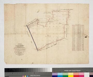
Plat of the Rancho Sausal-Redondo
Manuscripts
Bordered by Shoalwater Bay, ranchos San Pedro, Tajauta, La Ballona, Aguaje de la Centinela, Cienega o Paso de la Tijera. Containing 48,750 2/100 Acres. Color highlighting; section numbers, lines of previous surveys. Copy certified on September 24, 1870, by Sherman Day in the case of the "Tajauta, Sausal Redondo". Letter "B" in upper right corner. Alt title supplied by cataloger.
mssSolano SR_Map_0261

Plat of the Rancho Sausal Redondo
Manuscripts
Bordered by Pacific Ocean, Ranchos San Pedro, La Ballona and public lands Within stapled document, "Rancho Sausal Redondo Patent," p.17; approved & verified in 1875; showing township & lot numbers, courses, distances, posts, surface detailing; table of boundary data. Alt. title supplied by cataloger.
mssSolano SR_Box_25(10).01

Plat of the Rancho Sausal Redondo
Manuscripts
Bordered by ranchos San Pedro, La Ballona, Aguaje de la Centinela; Shoalwater Bay & Public lands. Finally confirmed to Antonio Ignacio Abila Containing 31,600 46/100 Acres. Numbered sections with bearings, distances, color highlighting, minor topographical details: portion of the Rancho called Guaspita. Inset with table of boundary data.
mssSolano SR_Map_0258
Plat of the Rancho Sausal Redondo
Manuscripts
Bordered by Shoalwater Bay, ranchos La Ballona, Cienega o Paso de la Tijera, Aguaje de la Centinela, San Pedro, Tajauta, public lands, and Los Angeles City lands. Finally confirmed to Antonio Ignacio Abila Containing 48750 02/100 Acres. Color highlighting, section numbers. Inset with table of boundary data.
mssSolano SR_Map_0260

Plat of the Rancho Sausal Redondo
Manuscripts
Bordered by ranchos San Pedro, La Ballona, Aguaje de la Centinela; Shoalwater Bay & Public lands. Finally confirmed to Antonio Ignacio Abila Containing 35880 46/100 Acres. Inset with table of boundary data. color highlighting, minor topographical details. Similar to Map 258 minus the sections detail.
mssSolano SR_Map_0259
Image not available
[Rancho Sausal Redondo]
Manuscripts
Collection of maps surveyed for the Los Angeles County Assessor's Office between 1860 and 1897. The maps primarily focus on excavations, improvements, and expansions of roads throughout Los Angeles, San Bernardino, and Orange Counties, with geographic coverage ranging from Malibu to Pomona and Newhall to San Juan Capistrano. Most of the maps show boundary lines of the various Ranchos existent throughout these counties, and many also include buildings, railroads, telegraph lines, land use, relief, and elements of the natural landscape such as canyons and rivers. Also included are maps showing the San Gabriel Mission, San Juan Capistrano Mission, and an elevation of the Los Angeles County court house. Some of the Ranchos depicted include San Antonio, Azusa, San Jose, Los Nogales, San Pedro, San Joaquin, San Rafael, Centinela, La Puente, Sausal Redondo, La Ballona, Rodeo-de-las-Aguas, Cienega, San Pasqual, and San Francisquito. Property shown includes that of Elias 'Lucky' Baldwin, Pio Pico, and Abel Stearns. The maps were originally housed in 16 bound volumes.
LARM_Vol_04_06.01