Manuscripts
Plat of Dimensions of Bacon's Hill at a horizontal cross section 33 feet from summit
You might also be interested in

Plat of Dimensions of Bacon's Hill at a horizontal cross section 33 ft. from the summit
Manuscripts
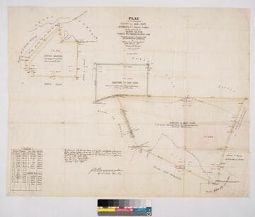
Rancho San Pasqual: Raymond Hotel plot outline (not labeled as such); table of stations and bearings; sketch annotations front & back. Bacon's Hill renamed Raymond Hill
mssSolano SR_Map_0185
Image not available
Plat of Dimensions of Bacon's Hill at a horizontal cross section
Manuscripts
The collection consists of maps, field books, legal documents, business papers, and diaries related to the work of surveyors George Hansen, Alfred Solano, Sidney B. Reeve, and others. The maps and surveys in the collection are of the city of Los Angeles, Southern California ranchos, and subdivisions of the city of Los Angeles and neighboring towns. The collection contains over maps and sketch maps. Other subjects represented in the collection include: civil engineering, land subdivision, mines and mineral resources, and daily life in Los Angeles and Los Angeles County.
mssSolano
Image not available
The Raymond: calculation of earth work finished Apr. 11, 1884. On verso: Plat of Dimensions of Bacon's Hill at a horizontal cross section
Manuscripts
The collection consists of maps, field books, legal documents, business papers, and diaries related to the work of surveyors George Hansen, Alfred Solano, Sidney B. Reeve, and others. The maps and surveys in the collection are of the city of Los Angeles, Southern California ranchos, and subdivisions of the city of Los Angeles and neighboring towns. The collection contains over maps and sketch maps. Other subjects represented in the collection include: civil engineering, land subdivision, mines and mineral resources, and daily life in Los Angeles and Los Angeles County.
mssSolano
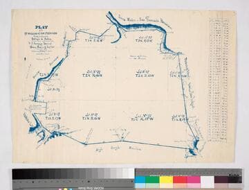
Plat of the ex Mission of San Fernando
Manuscripts
Bordered by Santa Susana Mtns., Sierra Madre or San Fernando Mtn., Tujunga Rancho, Rancho San Rafael, Providenicia y Cahuenga, High Rough Mtn., Rancho Las Virgenes. Finally confirmed to Eulogio de Celis . . . Var. 13° 30' East. Inset of table with courses & distances.
mssSolano SR_Map_0141
Plat of the Ranchos Azusa and San José and Additions of 1 Square League finally confirmed to Henry Dalton, Ygnacio Palomares & Ricardo Vijar
Manuscripts
Bordered by public lands, Rancho Los Nogales, Rancho Santa Ana del Chino, Rancho La Puente, Rancho of A. Duarte, Azusa Mountains. Addition is to Rancho San José. Colored borders. Hachures indicating hills. Variation 13° 30' East. Containing 27151 327/1000 acres. Surveyed under the Instructions from the U.S. Surveyor General - J.W. Mandeville signature. Inset of Field Notes table with coordinates and distances
mssSolano SR_Map_0008

Plat of the Rancho Sausal Redondo
Manuscripts
Bordered by Pacific Ocean, Ranchos San Pedro, La Ballona and public lands Within stapled document, "Rancho Sausal Redondo Patent," p.17; approved & verified in 1875; showing township & lot numbers, courses, distances, posts, surface detailing; table of boundary data. Alt. title supplied by cataloger.
mssSolano SR_Box_25(10).01