Rare Books
Map of Colfax County, New Mexico

You might also be interested in
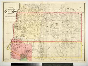
Sectional and Topographical Map of Colfax and Mora Counties Territory of New Mexico
Rare Books
Numerous changes have been made since the earlier map, 128069. "Compiled from the Original Plats in the Surveyor Generals Office Santa Fe, New Mexico. J. S. Taylor U. S. Deputy Surveyor, 1881." "Entered according to Act of Congress in the year 1882 by G.W. & C.B. Colton & Co. in the Office of the Librarian of Congress, at Washington." Prime meridian: GM. Relief: hachures. Graphic Scale: Miles. Projection: Cylindrical. Printing Process: Lithography. Verso Text: HL sticker: 128313.
128313
Image not available
Map of New Mexico
Rare Books
This map issued with Aztlan: the history, resources and attractions of New Mexico, by Wm. G. Ritch, Boston, 1885 See HL 152738. Prime meridian: GM. Relief: hachures. Projection: Cylindrical. Printing Process: Lithography. Verso Text: HL sticker: 128021.
128021
Image not available
Santa Fe Co. [New Mexico]
Rare Books
Showing mining districts and railroads. Another copy on William Gillet Ritch "A brochure from the New-Old West," Santa Fe, 1885, in which it was issued. "[Identifies] pre-European Pueblos in and near Santa Fe County." Prime meridian: GM. Relief: hachures. Projection: Cylindrical. Watermark: HL sticker: 127963. Printing Process: Lithography.
127963
Image not available
Map of the Texas Santa Fe & Northern Railroad as far as the South Border of the Territory of New Mexico, United States
Rare Books
This railroad had built a section of track between Santa Fe and Espanola, but projected a vast network of tracks across the state, already served by AT &SF Ry and others. Issued in London probably as a promotional piece. "Issued by the London Office of the Texas, Santa Fe & Northern Railway Company." Prime meridian: GM. Relief: hachures. Graphic Scale: Miles. Projection: Pseudocylindrical. Printing Process: Lithography. Verso Text: HL sticker: 127899.
127899
Image not available
Map of Bedford County Virginia
Rare Books
Note separate symbols for White School Houses and Colored School Houses. University of Virginia Library lists this map as ca. 1907. "By W. J. Hubard, C.E., Bedford City, Va." Relief: hachures. Graphic Scale: Miles. Projection: Plane. Printing Process: Lithography. Verso Text: Huntington sticker 116758.
116758
Image not available
Map of the Texas Santa Fe and Northern Railroad
Rare Books
Showing existing and projected railroads from Chicago to California. "Office, San Francisco Street, Santa Fe, New Mexico. October, 1882." "Copyright 1882 by Rand MaNally & Co." Prime meridian: GM. Relief: hachures. Projection: Cylindrical. Printing Process: Lithography. Verso Text: HL sticker: 128403.
128403