Rare Books
A plan of the town and harbour of Boston : and the country adjacent with the road from Boston to Concord ; shewing the place of the late engagement between the King's troops and the provincials, together with several encampments of both armies in & about Boston ; taken from an actual survey humbly inscribed to Richd. Whitworth Esqr. member of Parliament for Stafford / by his most obedient servant J. de Costa
You might also be interested in

Plan of the Town and Harbour of Boston. and the Country adjacent with the Road from Boston to Concord Shewing the Place of the late Engagement between the King's Troops & the Provincials, together with the several Encampments of both Armies in & about Boston. Taken from and Actual Survey. Humbly Inscribed to Rich. Whitworth Esqr. Member of Parliament for Stafford By his most Obedient Servant J. De Costa
Visual Materials
Kashnor notes, "The earliest battle plan issued in London after the Battle of Bunker Hill, which took place the 17th June, 1775. Up to the present only one copy has been recorded, and it is of the greatest rarity. Below the title are 19 references which locate the Men-of-War in Boston Harbour, General Gage's camp on the Commons, etc. It shows the attack on Concord, and locates the 'Bridge where the attack began,' with groups of soldiers of both forces firing upon each other, and 'Provincials firing behind the walls.' " Provincials are also named as "Minutemen." Many fighting figures. MS notes: Plan of the Town and Harbour of Boston 33 (faded). Relief: hachures. Graphic Scale: Miles. Projection: Plane. Watermark: Fleur-di-lis over shield and GB. Printing Process: Copper engraving. Other Features: Figures . Verso Text: MS notes: Plan of the Town and Harbour of Boston 33.
093:578 M
Image not available
Plan and profiles of surveys, from Farm Pond in Framingham and Long Pond in Natick, for supplying water to the City of Boston / L. Baldwin, Engineer
Visual Materials
No old shelf mark. Profile view of the water line. Relief: hachures. Graphic Scale: Miles, feet. Projection: Plane. Printing Process: Lithography.
ephMPMASS0002
Image not available
A new and correct map of the United States of North America : layd down from the latest observations and best authorities agreeable to the Peace of 1783 ; humbly incsribed to his Excellency the Governor and Company of the State of Connecticut by their most obedient and very humble servant Abel Buell
Rare Books
A reproduction in four sheets, hand colored with interesting state borders. Accompanied by printed explanation. Cartouche: Flag, Maid with liberty cap. Prime meridian: GM, Philadelphia. Relief: hachures. Graphic Scale: Miles. Projection: Pseudocylindrical. Printing Process: Lithography.
373302
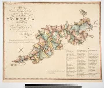
To Isaac Pickering Esqr of Fox Lease Hants this Plan of Tortola From actual Survey by George King is dedicated by His most obedient humble Servant Robt. Wilkinson
Visual Materials
Kashnor notes, "With a list of 104 plantations indicated on plan, with owners names." Pickering held the westernmost point of this island in the British Virgin Islands. Reference table listing owners and parcel numbers. MS note: 843 29. Prime meridian: GM. Relief: hachures. Graphic Scale: Miles, chains. Projection: Plane. Printing Process: Copper engraving. Verso Text: MS note: 843.
093:843 M
Image not available
Correct Plan of the Environs of Quebec, and of the Battle fought on the 13th. September, 1759: Together with a particular detail of The French Lines and Batteries, And also of the Encampments, Batteries and Attacks of the British Army, And the Investiture of that City under the Command of Vice Admiral Saunders, Major General Wolfe, Brigadier General Monckton, and Brigadier General Townshend. Drawn from the Original Surveys taken by the Engineers of the Army. Engraved by Thomas Jefferys, Geographer to His Majesty
Visual Materials
Kashnor notes, "with the exceedingly rare slip of the Plains of Abraham, showing the later movements of the armies, a fine impression of the rarest battle plan of the Old French War." Kashnor dates [1759]. Submap: Foldover insert on lower left labeled "Second plate".. Relief: hachures. Graphic Scale: Miles, feet. Projection: Plane. Printing Process: Copper engraving. Other Features: Sub-maps. Verso Text: MS note: 328.
093:328 M
Image not available
Map of Central America : including the states of Guatemala, Salvador, Honduras, Nicaragua & Costa Rica ; the territories of Belise & Mosquito ; with parts of Mexico, Yucatan & New Granada ; shewing the routes between the Atlantic & Pacific Oceans, by way of Tehuantepeque, Nicaragua & Panama / edited by Trelawney Saunders F.R.G.S., from the original drawing of John Baily Esqr. R.M. of Guatemala with additions from the latest surveys of the Admiralty, S. Moro, Col. Lloyd, Garella, Codazzi, Hughes, Childs & other documents, the railway surveys in Honduras contributed by the Hon. E. G. Squier, formerly Charge d'Affaires of the United States to the Republics of Central America
Rare Books
A record of the various proposals for routes through Central America. One note states, "The District of Socomusco formed part of Central America until 1843 when it was taken possession of by Mexico without treaty, and under protest by Guatemala against the occupation." Guatemala is still protesting. "London, Edward Stanford, Charing Cross. 1856." Elevations of 5 different routes shown. BM Maps, 2:224. Phillips, P.L. Maps of America, p. 216 (1879 reproduction in: Great Britain. Parliament. Accounts and papers, 1881, v. 99) Prime meridian: GM. Relief: hachures. Graphic Scale: Miles. Projection: Cylindrical. Printing Process: Lithography.
492533