Rare Books
Track Survey of the River Parana Sheet No. 3 ;(Paloma Island to Curumbe Island)
You might also be interested in
Image not available
Reference Chart to the Track Survey of the Tributaries if Rio la Plata
Rare Books
See 128052 for a similar map of the Parana River. "By Commander Thos. J. Page U.S.S. Water Witch 1855." Prime meridian: GM. Relief: no. Projection: Cylindrical. Printing Process: Lithography. Verso Text: HL sticker: 128534.
128534
Image not available
Track Survey of the River Uruguay with portions of the Rios Negro And Gualeguaychu. Sheet no. 1, Higueritas to Laguna and Sausal Islands
Rare Books
128054
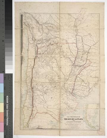
The provinces of the Rio de la Plata and adjacent countries : chiefly from the map constructed / by J. Arrowsmith for Sir Woodbine Parish, K.C.H., drawn by Augustus Petermann
Rare Books
Kirkpatrick Catalogue entry: "2458 d Arrowsmith, J. The provinces of the Rio de la Plata and adjacent countries, chiefly from the map constructed ... for Sir Woodbine Parish ... drawn by Augustus Petermann. [London], A. Petermann, [1850?]. 1 sheet. [see p.]."Includes section views: "Section from Raya Pass to Buenos Ayres through the Peru Bolivian Tablelands, and the Travesia and the Pampas of La Plata" and "Section from Valpraiso to Buenos Ayres." The map by Sir Woodbine Parish, on which this is based, was published in 1852. Martin de Moussy published his Description géographique et statique de la Confédération Argentina after this map, in 1860. (Técnica, política y "deseo territorial" en la cartografía oficial de la Argentina (1852-1941), Carla Lois, Scripta Nova, volume 10, number 218 (52), August 1 2006.) Probably obtained while Burton was in South America between 1865 and 1868. Submap: Section from Raya Pass to Buenos Ayres, through the Peru Bolivian Tablelands and the Traversia and the Pampas of La Plata; Patagonia and Tierra del Fuego. Stamp: Kensington Public Library. MS notes in Paraguay and Brazil.. Prime meridian: GM. Relief: hachures. Graphic Scale: Miles, leagues. Projection: Polyconic. Printing Process: Lithography. Other Features: Sub-maps. Verso Text: Stamp: Kensington Public Library (3).
623632
Image not available
Copy of survey of 1,030 acres on west side of Rivanna River, one mile below Milton
Manuscripts
Autograph manuscript, pen and ink. Copy made by Jefferson of William Tompkins survey conducted June 1812. (1 page)
HM 9403
Image not available
Preliminary Chart of James River Virginia : from Richmond to City Point Including the Appomattox River from Petersburg to the junction
Rare Books
Nine persons, all named, helped to make this navigational chart. "(C No. 4) " "Triangulation by J. Farley and W. P. Trowbridge, Lieut. U.S. Eng's. Assists.Topography by J. Seib and S. Wainwright Sub-Assists. Hydrography by the party under the command of Lieut. R. Wainwright, U.S.N. Assists. 1855 Red'd. Drng by W. T. Martin. Eng'd. by W. Langran and App. F. W. Benner. Verified H. W. Benham, Capt. of Eng'rs. Asst. C.S. in charge of Office." Prime meridian: GM. Relief: no. Graphic Scale: Miles. Projection: Plane. Printing Process: Lithography. Verso Text: HL sticker: 127900.
127900
Image not available
Copy of survey of land in Albemarle County
Manuscripts
Autograph manuscript, pen and ink. Copy by Jefferson of survey made by William Woods 1802 March 29 of 496 1/2 acres on the waters of Moore's Creek, surveyed for Thomas Wells Jr. (1 page)
HM 9393