Visual Materials
Karte von mittel-America oder Westindien : entworfen nach bewährten Hülfsmitteln von Fridr. Gottlieb Canzler, der Philosoph. Dr. zu Göttingen

You might also be interested in
Image not available
Charte von America : nach astronomischen Bestimmungen, den neuesten Nachrichten und Charten / entworfen von F.L. Güfsefeld [sic]
Visual Materials
Kashnor notes, "Locates Drake's Haven, San Bernardino, Monterey, Juan de Fuca Strait, Nootka, and a good coastline to Alaska." Prime meridian: Ferro. Relief: pictorial. Projection: Azimuthal. Watermark: Anchor? Figures?. Printing Process: Copper engraving. Verso Text: MS note: 227.
105:227 M
Image not available
Karte von Amerika : nach D'Anville und Pownall
Rare Books
Kashnor notes, "Shows the North-West Coast to the point where land was located by the Spaniards in 1775. The map of Alaska shows that it was indebted to the discoveries of Portlock and Dixon." Three submaps. Submaps: Karte von der Republik der Vereinigten Dreyzehen Staaten in NordAmerika; [Alaska]; [Hudson's Bay area]. Prime meridian: Ferro. Relief: pictorial. Graphic Scale: Miles. Projection: Conic. Watermark: Lettering. Printing Process: Copper engraving. Verso Text: MS note: 148975.
148975
Image not available
Charte von der Herschaft Jever : Nach astronomischen Bestimmungen, und im Lande selbst gemachten Zeichnungen, auch andren Hülfsmitteln entworfen / von F.L. Güssefeld
Rare Books
Area of today's Wilhelmshaven. Prime meridian: Ferro. Relief: no. Graphic Scale: Leagues. Projection: Plane. Watermark: Fluer di lis. Printing Process: Copper engraving.
279161
Image not available
Generalkarte von Nordamerica samt den Westindischen Inseln Verfasst von Herrn Pownall Neu herausgegeben von Herrn F. A. Schraembl MDCCLXXVIII (1788)
Visual Materials
Map in two sheets. Kashnor notes, "A rare issue of this map. Pownall based his work upon the maps of Lewis Evans, and this map contains valuable geographic knowledge of the Ohio and Illinois territory." Submap: Specialkarte von der Baffin und Hudsons Bai. Prime meridian: Ferro. Relief: pictorial. Projection: Pseudocylindrical. Watermark: Fleur-de-lis lettering. Printing Process: Copper engraving. Verso Text: MS notes: No. 102 210; No. 101.
105:624 M

Carte Réduite pour la Navigation de Cayenne a la Martinique. Dresée au Dépost des Cartes Plans et Journaux de la Marine Pour le Service des Vaisseaux du Roy Pare ordre de. M. le Duc de Choiseul Colonel Général des Suisses et Grisons, Ministre de la Guerre et de la Marine
Visual Materials
Inset map of Cayenne Harbor, French Guiana. Cartouche: shell and flowers. Submap: Carte de l'Entrée de Cayenne.. Prime meridian: Paris. Relief: pictorial. Graphic Scale: Leagues. Projection: Mercator. Watermark: Leaf-heart device lettering. Printing Process: Copper engraving. Other Features: CartoucheSub-maps. Verso Text: MS note: 472 .
105:472 M
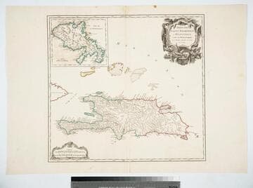
Isles de Saint Dominigue ou Hispaniola, et de la Martinique. Par le Sr. Robert, Geographe ord. du Roy, Avec Privilege. 1750
Visual Materials
Submap: Isle de la Martinique. Prime meridian: Ferro. Relief: pictorial. Graphic Scale: Leagues. Projection: Cylindrical. Watermark: Shield lettering. Printing Process: Copper engraving. Other Features: Sub-maps. Verso Text: MS note: 420 Stamped: St. Dominigue..
105:420 M