Visual Materials
America, laid down from the Observations of the Royal Academy of Sciences and compared with the Maps of Sanson, Nolin, Du Fer, de l'Isle, containing the several European Settlements both in North and South parts of America, agreeable to the latest accounts, particularly the British Empire in the northern part of America, with the adjacent Settlements of the French and Spaniards agreeable to Mr. Henry Popple's large Map, Moll and other newest and best Authorities
You might also be interested in

To the Right Honourable John Lord Sommers.; This Map of North America According to the Newest and most Exact Observations is most Humbly Dedicated by your Lordship's most humble Servant Herman Moll Geographer
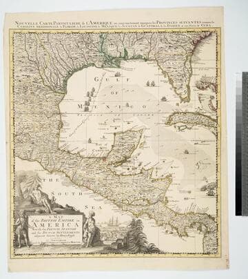
Visual Materials
Kashnor notes,"Shows a good map of the Far West, according to knowledge at the time particularly of New Mexico. California is still an island and there is a river which is in the locality of the Columbia." Map includes famous fish drying vignette, and is known as the "Cod Fish" map. McLaughlin dates as 1719. Note this is probably an earlier state, missing John King from map sellers mentioned by McLaughlin. Cartouche: Indians & Eskimos, Moll armorial. Fish drying vignette. Submaps: St John's Harbour, Boston Harbour, New York Harbour, Charlestown Harbour, Port Royal Harbour, Havana Harbour, Pto. Bello Harbour, La Vera Cruz, Cartagena Harbour, Port of Acapulco. . Prime meridian: London. Relief: pictorial. Projection: Azimuthal. Printing Process: Copper engraving. Other Features: CartoucheVignettesSub-maps. References: McLaughlin 192; Wagner 514; Wheat 105; Tooley 82; Leighly 145; Stevens No. 7; Goss 53 (plate).. Verso Text: MS notes: No. 7 G D 213.
093:213 M
Image not available
Map of the British Empire in America with the French and Spanish Settlements adjacent thereto by Hen. Popple
Visual Materials
Kashnor notes, "This is Popple's key map, with the rare inset view of New York. It is seldom that a colored copy occurs for sale." Kashnor dates as [1733]. Rosenthal confirms this as the index map for the 20 sheet Popple Atlas map published in 1733. Contain a quote from Edmond Halley praising Popple's map, several views. "Price 2 Shills." "W. H. Toms sculp." "To the Queen's most Excellent Majesty This Map is most humbly inscribed by Your Majesty's most Obedient and Most Humble Servant Henry Popple." Cartouche: Indians. Vignettes: Niagra Falls, Mexico City, Quebec City, New York City. Ships & sea battle. Submaps: Seventeen thumbnail maps of ports.. Prime meridian: London. Relief: pictorial. Projection: Mercator. Printing Process: Copper engraving. Other Features: CartoucheVignettesSub-maps. Verso Text: MS note: 583.
105:583 M

Map of the British Empire in America with the French and Spanish Settlements adjacent thereto by Henry Popple
Visual Materials
Four views and seventeen harbor submaps. Kashnor dates as 1734, other sources mention 1733. Views: Niagara Falls; Mexico [probably Vera Cruz]; Quebec; New York. Submaps: Seventeen small harbor and island maps along right edge.. Prime meridian: London. Relief: pictorial. Projection: Mercator. Printing Process: Copper engraving. Other Features: CartoucheVignettesSub-maps. References: Schwartz pl. 80.. Verso Text: MS note: 474.
093:474 M
Map of the British Empire in America With the French, Spanish and the Dutch Settlements adjacent thereto by Henry Popple
Visual Materials
Kashnor notes, "Copied from Popple's map With the titles in English and French. ShoWs Carolina divided into counites, With Georgia and the Forts neWly erected, and Savannah." Kashnor dates as ca. 1740, RLIN record suggests 1755. Cartouche of Indians, traders. MS note: No. 10. Relief: pictorial. Projection: Cylindrical. Printing Process: Copper engraving. Other Features: Cartouche. References: McCorkle [741.2]. Verso Text: MS note: 326.
105:326 M

A New Chart of the Coast of North America from Port Royal Entrance to Matanza Inlet Exhibiting the Coast of Georgia &c. by Captain N. Holland
Visual Materials
Three harbor submaps. Submaps: The Mouth of Nassau River; The Mouth of St Mary's River; Plan of the Harbour of St. Augustin.. Prime meridian: GM. Relief: no. Projection: Mercator. Printing Process: Copper engraving. Other Features: Sub-maps. Verso Text: MS note: 399.
105:399 M
Image not available
A New Chart of the Coast of Nova Scotia with the South Coast of New Brunswick; including also part of the Islands of St. John and Cape Breton, and of the Coast of New England : Regulated and Ascertained by Astronomical Observations by. Capt. Holland
Visual Materials
Note that date on map has been inked over and that this is a second edition, probably later. Contains submaps. Kershaw notes this as third state, supplies appeared in information. Submaps: Plan of River St. John; Plan of Port Roseway Harbour; Plan of the Entrance of Harbour of River of St. John. Views: Lighthouse Island; Chebucto Head; Cape Spry.. Prime meridian: London. Relief: hachures. Graphic Scale: Leagues. Projection: Cylindrical. Printing Process: Copper engraving. Other Features: VignettesSub-maps. References: Kershaw 806; L C Phillips 1236, 4476. Verso Text: MS note: 612.
105:612 M