Visual Materials
New and Correct Plan of the Harbour of Carthagena in America Seated 16 Degrees 26 Minutes Lat. North and 75 Degrees 21 Long. West of London, from a draught brought to England by Pet. Chassereau Archi: 1740. Also Several remarks concerning the Town of Carthagena & the Forts erected for its defence with a view of the French Ships commanded by De Pointis when he took the town in the year 1697
You might also be interested in

La Guadeloupe Dediée a Mr. Charles Philippe d'Albert Duc de Luynes, Pair de France Chevalier Commander des Ordres du Roy, Seigneur Usufruitier,du Duché de Chevreuse, des Comtés de Montfort, Prevoté, et Seigneurie d'Houdan y réunis, Marquis de Dangeau Baron de St. Hermine et autres Lieux. Par son trés humble et trés Obeissant Serviteur Le Rouge Ingr. Géographe du Roy
Visual Materials
RLIN record provides appeared in information. Cartouche: Flowered frame with crowned standing lion. Submap: l'Isle de Bourbon ou Mascareigne.. Relief: pictorial & hachures. Graphic Scale: Leagues. Projection: Plane. Printing Process: Copper engraving. Other Features: CartoucheSub-maps. Verso Text: MS note: 773.
093:773 M
Image not available
Particular Draught and Plans of some of the Principal Towns and Harbours belonging to the English, French, and Spaniards, in America and West Indies. Collected from the best Authorities. by Eman. Bowen
Visual Materials
Kashnor notes, "Boston Harbour, Placentia, Louisbourg, New York and Perth Amboy, Charles Town, Carolina, St. Augustine, Havana, Cartagena, Porto Bello, Etc." A total of thirteen maps on one sheet. MS note: 500 (on backing). Relief: pictorial. Graphic Scale: Miles. Projection: Plane. Printing Process: Copper engraving. Other Features: Sub-maps. Verso Text: MS note: 500 (on backing).
093:500 M
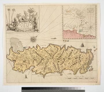
Island of Tobago by John Seller And are to be Sold at his Shop on the West side of the Royall Exchange And at the Hermitage in Wapping
Visual Materials
Kashnor dates as ca. 1680. Cartouche: Natives and animals. Submap: Cgart of the Carriby-Islands.. Relief: pictorial. Graphic Scale: Miles. Projection: Cylindrical. Printing Process: Copper engraving. Other Features: CartoucheSub-maps. Verso Text: MS note: 834.
093:834 M
Image not available
New Mapp of Magellan Straights Discovered by Capt. John Narbrough(Commander then of His Majestes Ship the Sweepstakes) as he sayled through the sade Stragihts. By John Thornton Hidrographer at the Platt in the Minories London
Visual Materials
Kashnor dates as ca. 1690. Note on map gives magnetic variation in 1670. Cartouche: Natives holding banner. Guard with Royal shield. Submap: Patagonia and Tierra del Fuego.. Prime meridian: Ferro. Relief: pictorial. Graphic Scale: Miles. Projection: Cylindrical. Printing Process: Copper engraving. Other Features: CartoucheSub-maps. Verso Text: MS note: 674 (on backing).
093:674 M
Image not available
A New Mapp of America Devided According to the Best and Latest Observations and Discoveries wherein are described by thear proper names the Seaverall Countries that Belonge to ye English which are wholly left out in French or Dutch maps viz New Scotland. Long Island. N. York. N. Jarsey. Mary Land. Pensilvania. Carrolina &. by Philip Lea at the Atlas and Hercules in Cheapside = and by J. Overton at the White Horse without Newgat London
Visual Materials
Kashnor notes, "an exceedingly rare map." Kashnor dates as ca. 1680. Cartouche: South American Natives. Submap: Arctic region, polar projection.. Prime meridian: Ferro. Relief: pictorial. Projection: Pseudocylindrical. Watermark: H. Printing Process: Copper engraving. Other Features: CartoucheSub-maps.
105:341 M

Carte Réduite pour la Navigation de Cayenne a la Martinique. Dresée au Dépost des Cartes Plans et Journaux de la Marine Pour le Service des Vaisseaux du Roy Pare ordre de. M. le Duc de Choiseul Colonel Général des Suisses et Grisons, Ministre de la Guerre et de la Marine
Visual Materials
Inset map of Cayenne Harbor, French Guiana. Cartouche: shell and flowers. Submap: Carte de l'Entrée de Cayenne.. Prime meridian: Paris. Relief: pictorial. Graphic Scale: Leagues. Projection: Mercator. Watermark: Leaf-heart device lettering. Printing Process: Copper engraving. Other Features: CartoucheSub-maps. Verso Text: MS note: 472 .
105:472 M