Visual Materials
Leffingwell Rancho lemon packing house, Los Angeles County (?). 1936

You might also be interested in
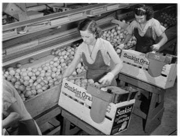
Orange packers, San Fernando Heights Citrus Packing House, Los Angeles County. 1938
Visual Materials
Young women pack crates of oranges in the San Fernando Heights Citrus Pack House. Wearing aprons and gloves, the young women stand in front of orange crates picking out oranges from a conveyor belt on their right. Each of the oranges is wrapped in paper and placed in the crate which has "Sunkist California Orange" labels on the ends, and the same stamped on the sides.
photCL Whitt 1615 ; Whitt neg. 1028
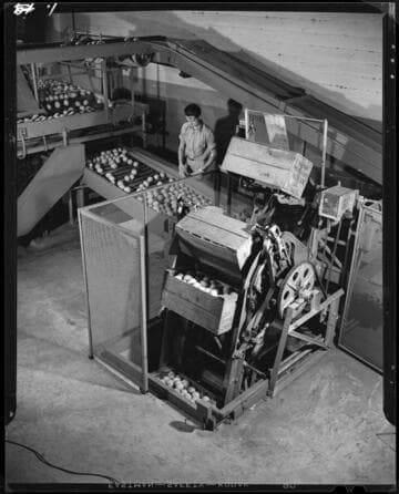
San Fernando Heights Packing House, Los Angeles County. 1938
Visual Materials
A young man watches oranges on a conveyor belt at the San Fernando Heights Packing House. The oranges, in crates stamped with "S.F.Hts. Orange Assn.", are raised along a vertical conveyor system and poured out onto the conveyor belt.
photCL Whitt 1611 ; Whitt neg. 1030

Arrowhead purity plant. 1946
Visual Materials
Two men and a woman work in a factory with large water bottles at the Arrowhead purity plant. There are two different kinds of bottles, each of which has Arrowhead Springs written on it. The men are putting the bottles in crates on a conveyor belt.
photCL Whitt 1631 ; Whitt neg. 1824
Typesetting, Los Angeles Times, Los Angeles. 1937
Visual Materials
Men in aprons and rolled shirt sleeves work at setting type at the Los Angeles Times. The men work at desks and machines and draw their letters from trays arranged around the room.
photCL Whitt 1460 ; Whitt neg. 1581

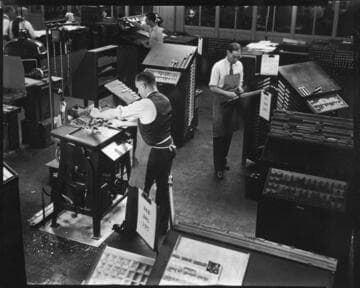
Typesetting, Los Angeles Times, Los Angeles. 1937
Visual Materials
Men in aprons and rolled shirt sleeves work at setting type at the Los Angeles Times. Almost twenty men are scattered at desks throughout the room, measuring and placing articles and illustrations in page layouts.
photCL Whitt 1459 ; Whitt neg. 1580
Image not available
Los Angeles County and Orange County Ranchos (1924-1936)
Visual Materials
A collection of photographs and maps compiled by American geologist and petroleum engineer Ralph Arnold (1875-1961), documenting his pioneering work in oil and mineral exploration, chiefly in the Western United States, Mexico and Venezuela, from 1900 to 1954. The collection centers on 64 photograph albums that span 50 years of Arnold's life and work. Photographs are accompanied by Arnold's typed captions identifying geological features; oil and mining activities; technical data; and dates and locations, i.e. often an oil or mining "district" or "field," such as "Sunset Field" (California). Subject matter includes geological and topographical features such as rock formations, faults and schisms, mountain structure, geothermal activity, and open land with potential drilling or mining spots. Earthquake faults are seen and described in many of Arnold's California investigations. There are also views of small and large-scale oil operations (by individuals and by organized companies); details of oil flow and reservoirs; asphalt; drilling equipment; workers and fields of oil wells. Arnold's work took him all over the Western United States, particularly California oil fields, but also Texas, Wyoming, Arizona, Alaska and other states. From 1911-1916 he was primarily in South America, and in the 1920s-1940s, mostly in the U.S., Canada and Mexico. Mining operations are the focus of some albums, showing investigations for tin, gold and other minerals; mines and ore processing, all with detailed descriptions. Arnold also often photographed people: colleagues and business associates, oil lease owners on their properties; workers (particularly Black and Asian workers in Venezuela); and friends and family. Personal photographs are throughout the album, such as of his wife, Winninette, and their two daughters; Stokes family members (Winninette's family) in South Pasadena; and alumni of Pasadena High School and Stanford University. Arnold was an avid gardener and the albums contain detail views of cactus and tropical plants, and scenes of Arnold collecting wild orchids in Trinidad, Venezuela and Mexico. The maps date from 1880-1948 and include U.S.G.S. and geological maps, California oil fields and well locations; layouts of mines, and various tract maps showing oil company-owned land.
photCL 311