Visual Materials
4th Street, Los Angeles, California, oil delivery wagon

You might also be interested in

Oil wells and residences on Alvarado Street, Los Angeles
Visual Materials
Image of an intersection at Alvarado Street and Ocean View Avenue (street names visible on corner sign) in the Westlake Park neighborhood of Los Angeles, California, with a Mission Revival house on the corner and oil wells in the background. Street railroad tracks can be seen in the dirt road. There are sprinklers and a man with a hose watering the lawn on the corner.
photCL_555_01_364
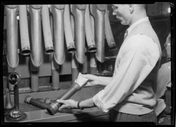
Pneumatic delivery system, Los Angeles Times, Los Angeles. 1941
Visual Materials
A man pulls paper clipped papers out of a pneumatic delivery tube at the Los Angeles Times. There are a series of ten tubes on the wall in front of him, and a telephone on the desk on the left.
photCL Whitt 1443 ; Whitt neg. 1226
Image not available
View on Pearl Street, Los Angeles
Visual Materials
View looking down the sidewalk of Pearl Street in Los Angeles, California, and showing the front yards, lawns, and gardens of residences, with a man watering a lawn with a garden hose.
photPF 24355

Thin to medium-bedded sandstone (oil bearing), looking northwest on Bellevue Avenue, north of Victor Street, Los Angeles, California
Visual Materials
Image of a cut through a hill showing the sandstone layers. An oil derrick is in the background.
photCL 311
Image not available
Map showing the Whittier-Fullerton Oil Field, Los Angeles and Orange counties, Union Oil Co. of California, Los Angeles (Feb. 1913)
Visual Materials
A collection of photographs and maps compiled by American geologist and petroleum engineer Ralph Arnold (1875-1961), documenting his pioneering work in oil and mineral exploration, chiefly in the Western United States, Mexico and Venezuela, from 1900 to 1954. The collection centers on 64 photograph albums that span 50 years of Arnold's life and work. Photographs are accompanied by Arnold's typed captions identifying geological features; oil and mining activities; technical data; and dates and locations, i.e. often an oil or mining "district" or "field," such as "Sunset Field" (California). Subject matter includes geological and topographical features such as rock formations, faults and schisms, mountain structure, geothermal activity, and open land with potential drilling or mining spots. Earthquake faults are seen and described in many of Arnold's California investigations. There are also views of small and large-scale oil operations (by individuals and by organized companies); details of oil flow and reservoirs; asphalt; drilling equipment; workers and fields of oil wells. Arnold's work took him all over the Western United States, particularly California oil fields, but also Texas, Wyoming, Arizona, Alaska and other states. From 1911-1916 he was primarily in South America, and in the 1920s-1940s, mostly in the U.S., Canada and Mexico. Mining operations are the focus of some albums, showing investigations for tin, gold and other minerals; mines and ore processing, all with detailed descriptions. Arnold also often photographed people: colleagues and business associates, oil lease owners on their properties; workers (particularly Black and Asian workers in Venezuela); and friends and family. Personal photographs are throughout the album, such as of his wife, Winninette, and their two daughters; Stokes family members (Winninette's family) in South Pasadena; and alumni of Pasadena High School and Stanford University. Arnold was an avid gardener and the albums contain detail views of cactus and tropical plants, and scenes of Arnold collecting wild orchids in Trinidad, Venezuela and Mexico. The maps date from 1880-1948 and include U.S.G.S. and geological maps, California oil fields and well locations; layouts of mines, and various tract maps showing oil company-owned land.
photCL 311

Los Angeles Basin Oil Fields
Visual Materials
Contour map of oil fields in Los Angeles, California. Details include names of landowners and oil companies and locations of oil wells. Map is attached to two wooden poles at top and bottom.
photCL 311