Visual Materials
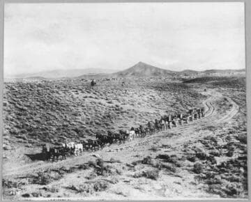
Method of hauling supplies to the prospect wells in the Coalinga District

You might also be interested in

Teaming lumber and supplies into Goldfield, Nevada, 1904
Visual Materials
A mule team pulling a wagon loaded with lumber. Lumber stacked on the ground in foreground.
photCL Pierce 06485

An unidentified teamster with his mule loaded with supplies in the mountains
Visual Materials
An unidentified teamster with his mule loaded with supplies in the mountains.
photCL SCE 04 - 00758

Eureka channel steel frame spring tooth harrow
Visual Materials
Image of a boy with a harrow pulled by a mule team in a farm field while two girls look on in an advertisement for Eureka Mower Company of Utica, New York; other farming machinery in fields in background.
priJLC_AGR_001770
Hauling supplies to the Mines. 20 horse and mule teams, Goldfield, Nevada. 1905
Visual Materials
A view of a 20 mule and horse team coming around a bend in a dirt road with Goldfield in the background.
photCL Pierce 06471
Image not available
Mailbox
Visual Materials
Image of a mailbox in the shape of a covered wagon pulled by an ox.
photCL MLP 2976.1
Image not available
California - Coalinga Oil District
Visual Materials
A collection of photographs and maps compiled by American geologist and petroleum engineer Ralph Arnold (1875-1961), documenting his pioneering work in oil and mineral exploration, chiefly in the Western United States, Mexico and Venezuela, from 1900 to 1954. The collection centers on 64 photograph albums that span 50 years of Arnold's life and work. Photographs are accompanied by Arnold's typed captions identifying geological features; oil and mining activities; technical data; and dates and locations, i.e. often an oil or mining "district" or "field," such as "Sunset Field" (California). Subject matter includes geological and topographical features such as rock formations, faults and schisms, mountain structure, geothermal activity, and open land with potential drilling or mining spots. Earthquake faults are seen and described in many of Arnold's California investigations. There are also views of small and large-scale oil operations (by individuals and by organized companies); details of oil flow and reservoirs; asphalt; drilling equipment; workers and fields of oil wells. Arnold's work took him all over the Western United States, particularly California oil fields, but also Texas, Wyoming, Arizona, Alaska and other states. From 1911-1916 he was primarily in South America, and in the 1920s-1940s, mostly in the U.S., Canada and Mexico. Mining operations are the focus of some albums, showing investigations for tin, gold and other minerals; mines and ore processing, all with detailed descriptions. Arnold also often photographed people: colleagues and business associates, oil lease owners on their properties; workers (particularly Black and Asian workers in Venezuela); and friends and family. Personal photographs are throughout the album, such as of his wife, Winninette, and their two daughters; Stokes family members (Winninette's family) in South Pasadena; and alumni of Pasadena High School and Stanford University. Arnold was an avid gardener and the albums contain detail views of cactus and tropical plants, and scenes of Arnold collecting wild orchids in Trinidad, Venezuela and Mexico. The maps date from 1880-1948 and include U.S.G.S. and geological maps, California oil fields and well locations; layouts of mines, and various tract maps showing oil company-owned land.
photCL 311