Visual Materials
South west Murrieta, looking across the valley

You might also be interested in

Depot at Murrieta, Santa Fe route
Visual Materials
Image of the Murrieta railroad depot of the Santa Fe Railroad in Murrieta, Riverside County, California.
photCL_555_01_1955
Image not available
Murrieta Colony : the new land of promise!
Visual Materials
Old shelf number: eph J4-13(7). Three maps on two sides of one sheet. Second map on recto: "Map of the Murrieta Portion of the Temecula Rancho, San Diego Co." Map on verso: "Map of parts of Los Angeles, San Bernardino and San Diego Counties." A piece extolling the virtues of the new town of Murrieta. The Temecula Land & Water Co. was only in Los Angeles directories between 1888 and 1890. Submap: Town site of Murrieta. Prime meridian: GM. Relief: no. Graphic Scale: Feet. Projection: Plane. Printing Process: Lithography. Verso Text: Map of Parts of Los Angeles, San Bernardino and San Diego Counties. Sales pitch.
ephMPCALIFT0088
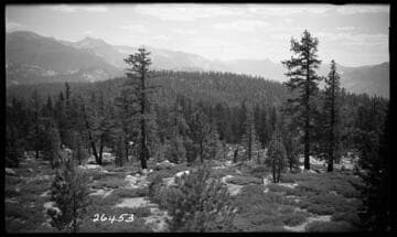
Vermilion Valley looking South across the Vermilion
Visual Materials
Vermilion Valley looking South across the Vermilion.
photCL SCE 02 - 26453

Fish Valley - Looking South across meadow
Visual Materials
Fish Valley - Looking South across meadow - South Portal of Upper Fish Creek Tunnel.
photCL SCE 02 - 26424
Image not available
161. Across Blue Canyon, looking West
Visual Materials
This collection contains 372 stereographic photographs (including some variants and duplicates) by photographer A. A. Hart that document the construction of the western half of first transcontinental railroad by the Central Pacific Railroad between 1864 and 1869. The collection includes all but seven of the original series, numbered from 1 to 364 by Hart (lacking 193, 323, 333, 358, 359, 362, and 364). The images chronicle the advancement of the railroad over 742 miles in California and the Sierra Nevada Mountains, Nevada, and Utah. The majority of the photographs are views of mountains, lakes, rivers, and forested areas (some with stumps from clear-cutting in the foreground), often with railroad tracks running through the center of the images. In addition, there are also images of locomotives, Chinese and other workers, equipment, bridges, tunnels, frontier and mining towns, construction camps, as well as some images of Native Americans, including Paiute and Shoshone Indians. The stereographs primarily contain Hart's own Sacramento imprint with series titles including: "Scenes in the Sierra Nevada Mountains"; "Scenes in the Valley of the Sacramento"; "Scenes in the Washoe Range"; "Scenes on the Humboldt River"; and "Scenes near Great Salt Lake". Interspersed in the collection are stereographs published without credit to Hart by Frank Durgan and Carleton E. Watkins.
photCL 184

Jersey Shore : looking south west Lycoming Co. Pa. 1854. : Bachelder's album of American scenery
Visual Materials
Image of an elevated landscape view looking southwest over Jersey Shore, Pennsylvania, and surrounding mountains, showing a couple on a cliff in the foreground looking over the town with a canal, and the Susquehanna River.
priJLC_VIEW_000549