Visual Materials
Beach road looking north towards Santa Monica Canyon

You might also be interested in

View from the bluff looking north toward the canyon, Santa Monica
Visual Materials
Image from the bluff looking north toward the intersections of Pacific Coast Highway with Entrada Drive and, a block north, with Channel Road and Chautauqua Boulevard in Santa Monica, California. With houses visible at right, automobiles on the Pacific Coast Highway and the beach at left. A Chevron Standard gasoline station can be seen near the intersection of Entrada Drive and a sign for "Gladstones 4 Fish" a block beyond.
photCL_555_06_2600

North Beach and Railroad, Santa Monica
Visual Materials
Image of North Beach and the Arcadia Hotel with the Southern Pacific Railroad tracks running next to the Beach Road in Santa Monica, California, in 1893. The Santa Monica Bath House and the remains of the Los Angeles and Independence Wharf are visible at right and the Palisades Bluffs are visible at left.
photCL_555_01_1224

Palisades Beach Road, Santa Monica
Visual Materials
Elevated view of houses along the beach in Santa Monica, California, looking south from the bluffs of Palisades Park, with railroad tracks and the Palisades Beach Road (part of the Roosevelt Highway, later Pacific Coast Highway), below, and the Santa Monica Pier and Ocean Park Pier visible in the distance. The mansion beach house of actress Marion Davies (which later became the Ocean House, or Oceanhouse hotel, and Sand and Sea Beach Club) is visible with multiple fireplaces in the foreground.
photCL_555_06_2551

Santa Monica Bath House and coast road
Visual Materials
View looking north on the coast road along Santa Monica beach (present day Pacific Coast Highway). The Palisades Park bluff is on the right, and automobiles are parked next to railroad tracks along the road. The Santa Monica Bath House is the large white building on the beach that says "Bath House" on the outside wall.
photCL_555_06_2563

Beach Road north of Santa Monica, Cal
Visual Materials
Image of the Beach Road north of Santa Monica, California (in present-day Pacific Palisades), with the Japanese fishing village next to the Long Wharf at upper right. The Santa Monica Canyon Beach House can be seen at the mouth of the canyon beyond the wharf, with the beaches of Santa Monica and the bluffs farther south.
photCL_555_09_91
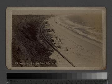
View south from Santa Monica Canyon
Visual Materials
Image of the cliffs and beach looking south from Santa Monica Canyon with the Arcadia Hotel in distance, and the Southern Pacific Railroad tracks running next to the Beach Road in Santa Monica, California. The remains of the Los Angeles and Independence Wharf are visible at upper right center of image.
photCL_555_01_1225