Visual Materials
People and cars travel down the California Incline to Pacific Coast Highway, Santa Monica

You might also be interested in

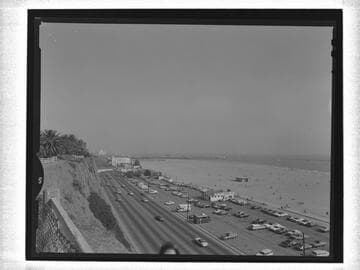
Pacific Coast Highway and coastline, Santa Monica
Visual Materials
View of automobiles on Pacific Coast highway and houses and other buildings along the beach as seen from Palisades Park in Santa Monica, California. The Sorrento Club is the building built into the cliff on the right.
photCL_555_01_1307

California Incline, Santa Monica
Visual Materials
Image of the California Incline road leading down to the coastal highway below the bluffs of Palisades Park in Santa Monica, California. The rustic wood branch fence is seen at the top of the bluffs and along the road. The Long Wharf is in the distance.
photCL_555_01_1318

Beach homes of the motion picture stars, Santa Monica, Cal
Visual Materials
Image of a section of celebrity beach houses along Palisades Beach Road (part of the Roosevelt Highway and later the Pacific Coast Highway) in Santa Monica, California, with the mansion of actress Marion Davies (which later became Ocean House, or the Oceanhouse Hotel and Sand and Sea Beach Club), in the foreground. The Sorrento Beach Club is seen in front of the California Incline road amid the bluffs at left and the Santa Monica Pier and Santa Monica Yacht Harbor breakwater are seen in the distance.
photCL_555_06_2156

Santa Monica coast road south of Santa Monica Canyon
Visual Materials
Image of automobiles on the Pacific Coast Highway south of Santa Monica Canyon, California, with the bluffs and Palisades Park and the California Incline in the distance at left and houses on the beach at right. The Santa Monica Pier is seen in the distance at center.
photCL_555_06_2591
Pacific Coast Highway looking south, Santa Monica
Visual Materials
Image of automobiles on the Pacific Coast Highway looking south in Santa Monica, California, with a parking lot, "Nancy's Refreshments," beach, and the Santa Monica Pier, in the distance, at right, and the cliffs and Palisades Park at left.
photCL_555_06_2592

California Incline and Palisades Park, Santa Monica
Visual Materials
Image of the California Incline road leading down to the coastal highway below the cliffs of Palisades Park in Santa Monica, California. The rustic wood branch fence is seen at the top of the bluffs and along the road. The Long Wharf is in the distance and a few buildings are on the sand, near the water.
photCL_555_01_1322