Visual Materials
Showing Point Duma and the Pacific

You might also be interested in

The Home Ranch. Point Duma, Malibu
Visual Materials
View of a ranch with fences, wagon, and horses. Identified as Point Duma (now called Point Dume), Malibu, California. It is unclear what the "home ranch" refers to.
photCL_555_06_102

"Malibu" No. of Santa Monica
Visual Materials
Image of the coastline, beach road, and Malibu Pier, with Malibu Point and Point Dume, in the distance in Malibu, California.
photCL_555_06_2046

Part of the Duma Ranch
Visual Materials
Landscape view of the canyons, trees, and hills of Malibu, California. There are a few small structures, possibly houses, in the canyon.
photCL_555_06_83
![Chatsworth from Stony Point [i.e. Stoney Point]](/_next/image?url=https%3A%2F%2Frail.huntington.org%2FIIIF3%2FImage%2F22APN46UQB2X%2Ffull%2F%5E360%2C%2F0%2Fdefault.jpg&w=750&q=75)
Chatsworth from Stony Point [i.e. Stoney Point]
Visual Materials
Bird's-eye-view of Chatsworth (San Fernando Valley), as seen from Stoney Point, near the north end of Topanga Canyon Boulevard. Most of the view shows agricultural crops and groves of trees.
photCL_555_01_1024
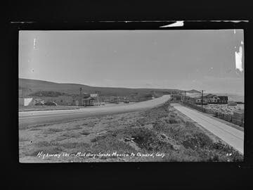
Highway 101 - Midway Santa Monica to Oxnard, Calif
Visual Materials
Image of the coastline looking south towards Point Dume from the Roosevelt Highway (later Pacific Coast Highway), and beach houses along Broad Beach near Trancas Canyon at Rancho Malibu, California, with the Malibu Trading Post, Cafe, cafe, Gilmore gas station, and a "Malibu Beaches" billboard visible.
photCL_555_06_2042

"No. 2 Point B" at Vermejo Ranch
Manuscripts
Black and white photograph of landscape. Snow on the ground in some areas, line of trees, hills in the distance. Note on verso reads: "No. 2 Point B on April 1, 1939."
mssLAT 01077