Manuscripts
Map showing property sought to be condemned for the widening of Hill Street between Sixth Street and Pico Street in the city of Los Angeles, Cal
Image not available
You might also be interested in
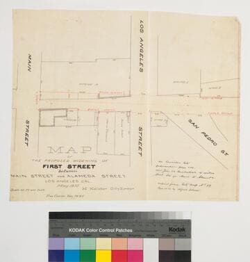
Map of the Proposed Widening of First Street between Main Street and Alameda Street
Manuscripts
P. 6 of stapled document, "House lot of Antonio Valla..." showing Main, Los Angeles & San Pedro streets, courses, distances, parcel owners; red highlighting. Copied by Alfred Solano.. Alt title supplied by cataloger.
mssSolano SR_Box_32(39).03
Image not available
Signal Hill properties -- [Widening of Hill St. Signal Hill]
Manuscripts
Administrative Series contains records relating to various facilitative operations within the Alamitos Land Company, including, but not limit to, account books, annual reports, appraisals, articles of incorporation, audits, balance sheets, bylaws, correspondence, financial records, financial statements, inventories, ledgers, legal documents, minutes, stock certificates, and titles (property rights). This series is organized alphabetically. A small number of oversize administrative records are stored under the Oversize Series. Commercial Properties Series include a wide-ranging type of records relating to the company's commercial and industrial portfolio. As per the original order, records are grouped under the headings of their respective commercial properties or projects, which include, but not limit to, Alamitos Beach Townsites, Alamitos Tract, Bixby Center, Bixby Ridge, Brawley Beef Packing Plant, Brawley Steam Wells, Firebaugh, Geothermal, Hathaway Apartments, Hathaway Business Park, The Knolls, Long Beach Tidelands, Luckey Ranch, Palo Verde and Spring Retail, Paramount Business Park, Recreation Park, Reservoir Hill, Rosemead Flair Business Park, Signal Hill East Unit, Tract 10548, U.S. Navy Depot, and the Willows Office Building. All commercial properties and projects were located within the State of California. This series is organized alphabetically.
mssAlamitos
Image not available
Map of the proposed widening of Washington Street between Vermont and Rosedale Avenues
Manuscripts
Collection of maps surveyed for the Los Angeles County Assessor's Office between 1860 and 1897. The maps primarily focus on excavations, improvements, and expansions of roads throughout Los Angeles, San Bernardino, and Orange Counties, with geographic coverage ranging from Malibu to Pomona and Newhall to San Juan Capistrano. Most of the maps show boundary lines of the various Ranchos existent throughout these counties, and many also include buildings, railroads, telegraph lines, land use, relief, and elements of the natural landscape such as canyons and rivers. Also included are maps showing the San Gabriel Mission, San Juan Capistrano Mission, and an elevation of the Los Angeles County court house. Some of the Ranchos depicted include San Antonio, Azusa, San Jose, Los Nogales, San Pedro, San Joaquin, San Rafael, Centinela, La Puente, Sausal Redondo, La Ballona, Rodeo-de-las-Aguas, Cienega, San Pasqual, and San Francisquito. Property shown includes that of Elias 'Lucky' Baldwin, Pio Pico, and Abel Stearns. The maps were originally housed in 16 bound volumes.
LARM_Vol_B_05.01
Los Angeles : Grasshopper Street, Sixth to Pico Street
Manuscripts
[Grasshopper Street is not indicated on map]. Extensions for 7th & 9th streets indicated, with survey notes; two courses listed. . Title supplied by cataloger.
mssSolano SR_Map_0432
Image not available
Maps of property necessary to be condemned
Manuscripts
Within fastened document, "Los Angeles Street Extension..." maps numbered No. 1- No. 15, with color highlighting; showing courses, distances, bordering parcel owners from Plaza/Olvera St./Negro Alley to Alameda St./Rimpau. Alt title supplied by cataloger.
mssSolano SR_Box_29(38).01A.08
Image not available
Maps of property necessary to be condemned
Manuscripts
Within fastened document, "Los Angeles Street Extension..." maps numbered No. 1- No. 15, with color highlighting; showing courses, distances, bordering parcel owners from Plaza/Olvera St./Negro Alley to Alameda St./Rimpau. Alt title supplied by cataloger.
mssSolano SR_Box_29(38).01A.14