Manuscripts
Surveying notes on California ranchos
Image not available
You might also be interested in
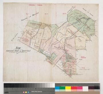
Map of that part of the Rancho Paso de Bartolo in the County of Los Angeles showing the partition
Manuscripts
Bordered by Ranchos San Antonio, Rancho La Merced, Potrero de Felipe Lugo, La Puente, Town of Whittier. Color highlights, highly detailed land features. Copy of previous map minus notes on court case references.
mssSolano SR_Map_0106.02

Map showing the Jesurun & Broderick lands in the Rancho Paso de Bartolo
Manuscripts
Bordered by Ranchos San Antonio, La Merced, Potrero de Felipe Lugo, La Puente. Indicates rival boundaries between Rancho Paso de Bartolo and the ranchos la Puente, Potrero de Felipe Lugo and la Merced. Color highlights; Rio Hondo, New San Gabriel rivers, and landowners indicated. Based on surveys by Solano, Solano & Stevenson, Ellis & Rowan.
mssSolano SR_Map_0107

Plat of the Rancho Paso de Bartolo.; finally confirmed to Pio Pico and Juan Perez
Manuscripts
Bordered by Ranchos San Antonio, La Merced, La Puente, Santa Gertrudes; property of McFarland & Downey. Bound within document: "Field Notes and Map of the Rancho Paso de Bartolo..." (Hansen) Showing San Gabriel River, subdivided public lands, townships & section numbers, courses & distances, structures, surface details; with survey notes, table of boundaries, certification; colored inks. Alt. title supplied by cataloger.
mssSolano SR_Box_22(07).14

Plat of the Rancho Sausal Redondo
Manuscripts
Bordered by ranchos San Pedro, La Ballona, Aguaje de la Centinela; Shoalwater Bay & Public lands. Finally confirmed to Antonio Ignacio Abila Containing 31,600 46/100 Acres. Numbered sections with bearings, distances, color highlighting, minor topographical details: portion of the Rancho called Guaspita. Inset with table of boundary data.
mssSolano SR_Map_0258
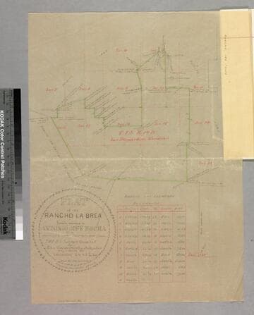
Plat of the Rancho La Brea finally confirmed to Antonio Jose Rocha
Manuscripts
Bordered by Ranchos San Antonio (or Rodeo de las Aguas), Las Cienegas, Los Felis and public land. Sixth page of document, "Rancho La Brea Patent," with color highlighting, talbe of boundary data; shows structures, courses, distances, section numbers, hachures, stations
mssSolano SR_Box_20(10).02

Map of that part of the Rancho Paso de Bartolo in the County of Los Angeles showing the partition.;(Map A)
Manuscripts
Bordered by Ranchos San Antonio, Rancho La Merced, Potrero de Felipe Lugo, La Puente, Town of Whittier. Referees in partition Alfred Solano, John E. Jackson, Thomas E. Rowan decreed by LA Superior Court Dec 27, 1893. Color highlights, hachures, landowners, roadways (Workman Mill Road), waterways indicated.
mssSolano SR_Map_0106.01