Opening Hours
Daily: 10 A.M.–5 P.M.
Closed on Tuesdays
1151 Oxford Road
San Marino, CA 91108
Daily: 10 A.M.–5 P.M.
Closed on Tuesdays
1151 Oxford Road
San Marino, CA 91108

Image not available
Manuscripts
[Map proposed electric R.R. to San Joaquin Valley]
mssGibbon
Image not available
Visual Materials
This collection contains 71 lantern slides of primarily unidentified scenes including slides depicting people, children, scenery, and farming. Many of these scenes appear to be in the Southern California area, though there are a few from other locales including Canada and England. Among the identified slides are Mission San Gabriel; Champlain Monument in Quebec, Canada; a 1798 letter to the Maryland Free Masons; the steamship "Parisian" in Liverpool, England; Palmdale, California train station; the 1925 Santa Barbara earthquake; and Lucky Baldwin's Ranch in Arcadia, California. Photographers are not identified.
photCL 518
Image not available
Rare Books
A large map showing railroads, oil fields, and dry "Salton Lake." "Copyrighted 1901 Stoll & Thayer Co." "Compiled & Drawn by N. B. Blunt." Prime meridian: GM. Relief: hachures. Graphic Scale: Miles. Projection: Cylindrical. Printing Process: Lithography. Verso Text: MS note: 139325.
139325
Rare Books
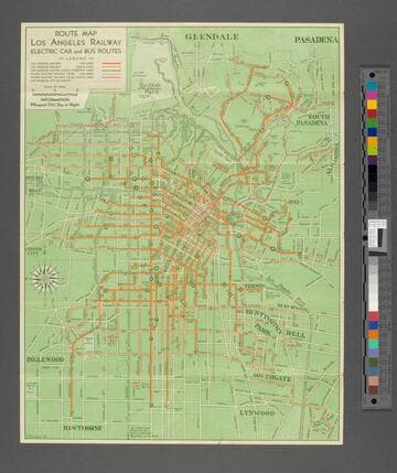
Alt. title from cover. Route information and central bird's-eye view map on verso. Prime meridian: GM. Relief: no. Graphic Scale: Miles. Projection: Cylindrical. Printing Process: Lithography. Verso Text: Route descriptions plus central city map.
403717
Image not available
Visual Materials
Old shelf number Eph J2d. A busy map with postal code zones, street car and bus routes plus train tracks. See also RB ephMPCALIFR0021 for a 1931 version of this map; see RB ephMPCALIFR0022 for a 1934 version. Street Index. Prime meridian: GM. Relief: no. Graphic Scale: Miles. Projection: Plane. Printing Process: Lithography. Verso Text: Submaps: Highway map of California Nevada; Map of San Fernando Valley addition to the City of Los Angeles.
ephMPCALIFR0018
Image not available
Visual Materials
Old shelf number Eph J2d. A map with postal code zones, street car and bus routes plus train tracks. See also RB ephMPCALIFR0018 for a 1943 version of this map; see RB ephMPCALIFR0022 for a 1934 version. This map complete with cover for folding. Street Index Submap: City of Inglewood. Prime meridian: GM. Relief: no. Graphic Scale: Miles. Projection: Plane. Printing Process: Lithography. Verso Text: Submaps: Map of San Fernando Valley Addition to the City of Los Angeles Map of Pasadena; Map of Alhambra Hill's Map of South Los Angeles and Harbor District.
ephMPCALIFR0021