Rare Books
Hand-book and map to the gold region of Frazer's and Thompson's rivers : with table of distances
Image not available
You might also be interested in
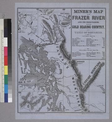
Miner’s Map of Frazer River and it’s Tributaries With the Gold Bearing Country
Rare Books
Image is a topographical map of the area from Snoqualmoo Pass in the southeast to Big Falls in the north, and from Vancouvers Island in the west to L. Chelan in the east. Notable features on the map include the Gulf of Georgia, Puget Sound, Frazer's River, and the Cascade Mountains. Locations of coal, gold, digging sites, and Indian diggings are labeled on the map. In the upper right corner is a table of distances, and in the upper left corner is a map of Indian trails. "Whitton, Towne & Co's Print, 125 Clay St., San Francisco. Sold by J. W. Sullivan, News Agent, San Francisco. S. F. Baker. Engr. 159 Clay St."--text, below image. Paper color: blue.
48052:154
Image not available
The Frazer river thermometer : Great gold discoveries of 1858. The Frazer river gold mines, and their history
Rare Books
220632
Image not available
Philip's map of British Columbia and Vancouver Island with the Frazer River gold diggings / by J. Bartholomew F.R.G.S
Rare Books
Alt. title from cover. Washington and Oregon extend to the Rocky Mountains on the east. Prime meridian: GM. Relief: hachures. Graphic Scale: Miles. Projection: Polyconic. Printing Process: Lithography.
41404
Image not available
A New Map of the Gold Region in California
Rare Books
Accompanied by a written description of California. Note that turning point is shown to the west of Mountain Lake (Lake Tahoe) which would have been easier to survey than the actual turning point. "By Charles Drayton Gibbes. From his own and other Recent Surveys & Explorations 1851." "Entered according to Act of Congress in the year 1851 by Sherman & Smith in the Clerk's office of the District Court for the Southern District of New York." Cover title: Accompaniment to Gibbes' New Map of the Gold Region in California. Ms note: 131781. Prime meridian: GM. Relief: hachures. Graphic Scale: Miles. Projection: Polyconic. Printing Process: Lithography.
131781
Image not available
Map of the gold region, California, 1851
Rare Books
Somewhat inaccurate map: Tahoe is labeled "Preemont Lake"; the State line is drawn to the east of the lake. Prime meridian: GM. Relief: hachures. Projection: Polyconic. Printing Process: Lithography.
433056