Rare Books
Geographic and hydrographic descriptions of many northern and southern lands and seas in the Indies, specifically of the discovery of the kingdom of California (1632)
Image not available
You might also be interested in
Image not available
A geographical description of the state of Louisiana : the southern part of the Mississippi, and the territory of Alabama
Rare Books
15699
Image not available
Considerations geographical and physical on the new discoveries north of the Great Sea, commonly called the South Sea; with maps relative thereto
Manuscripts
Manuscript English translation.
mssHM 210
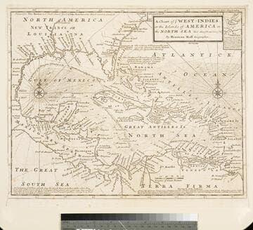
Chart of the West Indies or the Islands of America in the North Sea &c. Being the Present Seat of War. by Herman Moll Geographer
Visual Materials
Kashnor notes, "Shows the mainland around the Gulf of Mexico, with Louisiana, Florida, Georgia, and Carolina." Kashnor dates as ca. 1719. Submap: Vera Cruz harbor. Sailing instructions for galleons. MS note: 321 (on backing). Prime meridian: London. Relief: no. Projection: Cylindrical. Watermark: Two devices. Printing Process: Copper engraving. Other Features: Sub-maps.
105:321 S
Image not available
Maritime Flags of all Nations, Together with a Geographical Description of every Empire, Kingdom, and Republic of the World
Rare Books
71148
Image not available
A description of peculiar charts and tables, for facilitating a discovery of both the latitude and longitude, in a ship at sea;
Rare Books
494061