Rare Books
[Map of San Francisco, with Horners addition]
Image not available
You might also be interested in
Image not available
Map of San Francisco
Rare Books
Previous folder indicates dates of publication. Prime meridian: GM. Relief: no. Graphic Scale: varas. Projection: Plane. Printing Process: Lithography. Verso Text: MS note: 217759.
217759
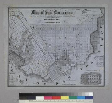
Map of San Francisco
Rare Books
Image is of a map of the downtown area with a vignette of Parrott Block in the lower right corner. The map covers the area from waterfront to Webster, and from North Point to Addition of Mission. At the lower left are nine letter identifications of public buildings on the map and symbols for other locations. At the right are twelve letter identifications for places of worship. "Published by Britton & Rey, San Francisco Cal."--text, below title of map. "Page Bacon & Co. Adams & Co."--text, above vignette in lower right corner. Paper color: blue.
48052:138
Image not available
Syndicates first addition to San Francisco
Visual Materials
Old shelf number: eph J4-3 (13). The West End Homestead, depicted here to the southwest of the Syndicates Addition, was north and south of the county line dividing San Francisco and San Mateo Counties, near Mission Street. The addition is now in the Crocker-Amazon neighborhood. MS note: 3-. Prime meridian: GM. Relief: no. Graphic Scale: Feet. Projection: Plane. Printing Process: Lithography. Verso Text: MS note: Syndicate Land Co. of -----.
ephMPCALIFT0035
Image not available
Map of the gold region, California, 1851
Rare Books
Somewhat inaccurate map: Tahoe is labeled "Preemont Lake"; the State line is drawn to the east of the lake. Prime meridian: GM. Relief: hachures. Projection: Polyconic. Printing Process: Lithography.
433056