Rare Books
Governor Murray's journal of the siege of Quebec. : From 18th September, 1759 to 25th May, 1760
Image not available
You might also be interested in
Image not available
An accurate and authentic journal of the siege of Quebec, 1759. : By a gentleman in an eminent station on the spot
Rare Books
138710
Image not available
War: : an heroic poem. From the taking of Minorca by the French, to the raising of the siege of Quebec, by General Murray
Rare Books
138706
Image not available
Authentic Plan of the River St. Laurence from Sillery to the Fall of Montmorenci, with the Operations of the Siege of Quebec with the Command of Vice-Adml. Saunders & Major Genl. Wolfe. 1759
Visual Materials
This map appears to be a reduced size copy of Jefferys' map, 093:325 and 093:325A. The engraving is less detailed and the dedication is missing. The RLIN record cited refers to this map since it mentions title within ornamental cartouche. RLIN record dates as 1760? See also 105:674. Cartouche surrounds title. MS note: 326 (on backing) Undecipherable penciled note, trimmed at top. Submaps: Part of the Upper St. Lawrence River; A view of the action gain'd by the English Sepr. 13. 1759.. Relief: hachures. Graphic Scale: Miles. Projection: Plane. Printing Process: Copper engraving. Other Features: Cartouche. Verso Text: MS note: 326 (on backing).
093:326 S
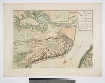
Plan of the City and Environs of Quebec with its Siege and Blockade by the Americans, from the 8th of December 1775 to the 13th of May 1776
Visual Materials
Kashnor notes, "A very fine war plan, in colours, showing where Montgomery made his attack and the emplacement of batteries." A stunning map. Kershaw supplies appeared in information. Relief: hachures. Graphic Scale: Yards. Projection: Plane. Watermark: Crowned fluer-di-lis W F. Printing Process: Copper engraving. References: Kershaw 1041; LC Phillips 1207,1337.. Verso Text: MS note: 120.
093:120 M
Image not available
A Plan of the River St. Laurence, from Sillery to the Fall of Montmorenci, with the Operations of the Siege of Quebec under the Command of Vice-Adml. Saunders & Major Genl. Wolfe. 5 Sepr.1759
Visual Materials
This map is John Cary's version of 105:674 and related maps by Jefferys 093:326 et al. This map follows 105:674 closely. Same submaps. Kashnor dates as [1760]. MS note: 679 (on backing) Submaps: Part of the Upper St. Lawrence River; A view of the action gain'd by the English Sepr. 13. 1759 near Quebec.. Relief: hachures. Graphic Scale: Miles. Projection: Plane. Printing Process: Copper engraving. Other Features: Sub-maps. Verso Text: MS note: 1723.
105:679 S

Plan of the City and Environs of Quebec, with its Siege and Blockade by the Americans : from the 8th of December 1775 to the 13th of May 1776 / Engraved by Wm. Faden
Rare Books
Prime meridian: GM. Relief: hachures. Graphic Scale: Yards. Projection: Plane. Watermark: WF; crowned shield. Printing Process: Copper engraving. Verso Text: MS note: 16.
291460