Rare Books
Map of the town of Baldwin in the Santa Anita tract, San Gabriel Valley, Los Angeles county, Cal
Image not available
You might also be interested in
Image not available
Map of a part of Santa Anita Tract San Gabriel Valley Los Angeles Co., Cal
Rare Books
Santa Anita Avenue on the west, Mayflower Avenue on the east, County Road (now Duarte Road) to the south, Grand View Avenue to the north. "H. J. Stevenson, Sur. Sept., 1886." "H. A. Unruh 57, North Spring St., Los Angeles." Relief: no. Graphic Scale: Feet. Projection: Plane. Printing Process: Lithography. Verso Text: MS notes: Map of Santa Anita 442361.
442361
Image not available
Map of a part of Arcadia Santa Anita Tract Los Angeles Co., Cal. 1887
Rare Books
Santa Anita Avenue to the west, Fifth Avenue to the east, Orange Avenue to the north, Diamond Street to the south. "H. J. Stevenson, Surveyor." "H. A. Unruh 57, North Spring St., Los Angeles." Relief: no. Graphic Scale: Feet. Projection: Plane. Printing Process: Lithography. Verso Text: MS note: Arcadia.
442358

Anita Cottage, San Gabriel Valley, Cal
Visual Materials
View of cottages that comprised part of the Sierra Madre Villa hotel in what is now Sierra Madre, California, in the foothills of the San Gabriel Mountains, with men and women on the porches, and a child with a baby carriage on the dirt path. Small trees are planted in the foreground.
photCL 555
Image not available
Lucky Baldwin's Santa Anita's Ranch, San Gabriel, Cal. [Photographer: I.W. Taber]
Visual Materials
This album contains typical commercial photographs of the towns and scenery of California, Oregon and Washington dating from the 1890s. Of note are early views of San Diego, Santa Barbara, San Luis Obispo, San Francisco, Tacoma, and Seattle. There are also views of California missions and coastal landscapes. The Oregon photographs are of scenery only. Photographs of California include San Diego; Casa de Estudillo in Old Town San Diego; Mission San Luis Rey, San Juan Capistrano, and Santa Barbara; Santa Barbara; San Luis Obispo; Confederate general James Longstreet's Los Angeles home; the Bellevue Terrace Hotel; various Los Angeles homes; Pasadena; Elias Jackson "Lucky" Baldwin's Santa Anita ranch; San Francisco city scenes; and wilderness en route to Oregon. Oregon photographs show images of the Columbia River; Mt. Hood; Latourell Falls; Multnomah Falls; and nature scenes. Photographs of Washington state include Tacoma; Green River; Native Americans from an unidentified tribe; Seattle; and Angeline, the daughter of Chief Seattle of the Suquamish tribe. Twenty-six of the pictures in this album were photographed by Isaiah West Taber and twenty-two were photographed by W.H.J. and Company. It may be that William H. Jeffers created those twenty-two photographs, as he was active in California during this time period. Other photographers who contributed to this album include Thomas H. Rutter, Charles B. Talbot, and Boyd & Braas (William F. Boyd and George H. Braas). The initials "E.B.R." and the year 1897 are embossed on the photo album's spine.
photCL 94
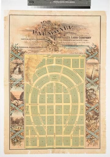
Map of Palmdale : property of the Palm Valley Land Company, San Diego County, Cal. / Surveyed January 1888 by H. J. Stevenson
Rare Books
The projected town of Palmdale, three miles east of Palm Springs, in a portion of San Diego County which later became part of Riverside County, eventually vanished--Cf. P.T. Hann... Dict. Calif. land names. "Subdivision of S.W. 1/4 and S. 1/2 of the N.W. 1/4 of Section 25.T.4 S.R. 4 E. S.B.M." Vignettes: Lush tropical growth. Prime meridian: GM. Relief: hachures. Graphic Scale: Feet. Projection: Plane. Printing Process: Lithography. Verso Text: Stamp: 9395 MS Notes: Palmdale 1888, San Diego Co. 471218.
471218
Image not available
Map of Azusa Los Angeles Co., Cal
Rare Books
Centers on Azusa Avenue, First Street on the south, Eleventh Street on the north. MS notes: Notes regarding lots sold and use.. "H. J. Stevenson, Surveyor." Relief: no. Graphic Scale: Feet. Projection: Plane. Printing Process: Lithography. Verso Text: MS note: 83 Lines.
215833