Rare Books
A complete system of geography. : Being a description of all the countries, islands, cities, chief towns, harbours, lakes, and rivers, mountains, mines, &c. of the known world. Shewing the situation, extent, and boundaries, of the several empires, kingdoms, ... To which is prefixed, An introduction to geography, ... In two volumes. The whole illustrated with seventy maps, by Emanuel Bowen, ... making, of themselves, a complete atlas, ... This work, extracted from several hundred books of travels and history, is brought down to the present time; preserving all that i useful in the fourth and last edition of the complete [sic] geographer, publish'd under the name of Herman Moll, &c
Image not available
You might also be interested in

The Island of Jamaica Divided into its Principal Parishes with the Roads &c. / By Herman Moll, Geographer
Rare Books
From Moll's "Atlas Minor," 1728 ("The Printed Maps of Jamaica up to 1825," Capt. Kit S. Kapp in The Map Collectors' Circle, No. 42). MS note: 74. Prime meridian: London. Relief: pictorial. Graphic Scale: Miles. Projection: Plane. Printing Process: Copper engraving.
295825
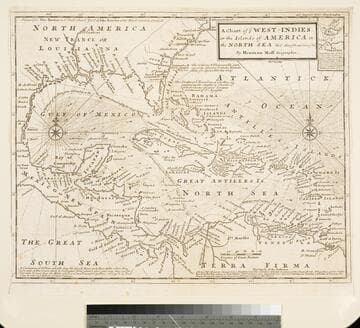
Chart of the West Indies or the Islands of America in the North Sea &c. Being the Present Seat of War. by Herman Moll Geographer
Visual Materials
Kashnor notes, "Shows the mainland around the Gulf of Mexico, with Louisiana, Florida, Georgia, and Carolina." Kashnor dates as ca. 1719. Submap: Vera Cruz harbor. Sailing instructions for galleons. MS note: 321 (on backing). Prime meridian: London. Relief: no. Projection: Cylindrical. Watermark: Two devices. Printing Process: Copper engraving. Other Features: Sub-maps.
105:321 S
![Chart of the West-Indies or the Islands of America in the North Sea &c. [Being the Present Seat of War] (probably added by Bowles) by Herman Moll Geographer](/_next/image?url=https%3A%2F%2Frail.huntington.org%2FIIIF3%2FImage%2F22APN4KV8V8V%2Ffull%2F%5E360%2C%2F0%2Fdefault.jpg&w=750&q=75)
Chart of the West-Indies or the Islands of America in the North Sea &c. [Being the Present Seat of War] (probably added by Bowles) by Herman Moll Geographer
Visual Materials
Kashnor notes, "A re-issue of Moll's map at the time of Vernon's expedition. Bowles appears to have secured possession of all of Moll's plates." Kashnor dates as ca. 1740. MS notes: 714 (upper left and on backing). Submap: La Vera Cruz.. Prime meridian: London. Relief: no. Projection: Cylindrical. Printing Process: Copper engraving. Other Features: Sub-maps.
093:714 S