Rare Books
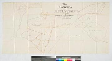
Map of a portion of Los Angeles county showing the Abel Stearns' ranchos : 5 ranchos 200 square miles in blocks of 1 mile square with road on each side. For sale in sections or fractions, by Alfred Robinson, trustee, at the Los Angeles & San Bernardino land office ... San Francisco, or apply to the agency, Los Angeles or Anaheim
Image not available
You might also be interested in
Image not available
Map of a portion of Los Angeles County showing the Abel Stearns Ranchos
Rare Books
Alfred Robinson is the trustee for the Los Angeles and San Bernardino Land Office in San Francisco presiding over the breakup of the Abel Stearns lands in current Los Angeles and Orange counties. Relief: hachures. Projection: Cylindrical. Printing Process: Lithography. Verso Text: MS note: 219201.
219201
Image not available
Rancho Los Alamitos... owned by Abel Stearns
Manuscripts
The collection consists of maps, field books, legal documents, business papers, and diaries related to the work of surveyors George Hansen, Alfred Solano, Sidney B. Reeve, and others. The maps and surveys in the collection are of the city of Los Angeles, Southern California ranchos, and subdivisions of the city of Los Angeles and neighboring towns. The collection contains over maps and sketch maps. Other subjects represented in the collection include: civil engineering, land subdivision, mines and mineral resources, and daily life in Los Angeles and Los Angeles County.
mssSolano
Map of the Ranchos Belonging to Abel Stearns in the Counties of Los Angeles, San Bernardino
Manuscripts
Showing surface details, structures, acreage, San Gabriel River; Stearns' parcels outlined in color. Alt title supplied by cataloger.
mssSolano SR_Box_32(27).04

Rancho Los Alamitos owned by Don Abel Stearns
Manuscripts
Bordered by the Pacific Ocean, Rancho Los Sierritos [Cerritos], Rancho Bolsa Chica,. Rancho Los Coyotes. [Map must be after February 23, 1857 when district court affirmed the claim.]. Inset of table listing distances. Magnetic Meridian Var. 13° 30' east. T. 4 S.R. 11 W.. T. 5 S.R. 11 W.. T. 4 S.R. 12 W.. Color highlights. Includes wetlands and waterways, hachures. Originally granted to Don Juan Jose Nieto by Governor Jose Figueroa 1833
mssSolano SR_Map_0005
Image not available
Abstract and title to land in Los Angeles, Orange, and San Bernardino counties owned by Abel Stearns and conveyed to Alfred Robinson and the Stearns Ranchos Co
Manuscripts
mssHM 29311

Los Angeles : Tract of the Mill Seat of Abel Stearns
Manuscripts
Traced from Hansen's map of the Millseat of Messrs Mellus Scott and Stearns, Aug. 3, 1856. Notation re: Southern Pacific Railroad. Virgin Street to L.A. River; block numbers, cemetery. Hachures, structures, color highlights, parcel owners (Luis Wilhard, Manual Romero) indicated. Title supplied by cataloger.
mssSolano SR_Map_0417