Rare Books
An Account of the distances from the city of Philadelphia, of all the places of note within the improved part of the province of Pennsylvania. : Note. The distances are not to be understood in a right line, but as the road is laid out from one place to another; for instance, from Shippensbourg to Rays-Town measures sixty-one miles along the road; whereas the nearest distance of these places is but fifty miles
Image not available
You might also be interested in

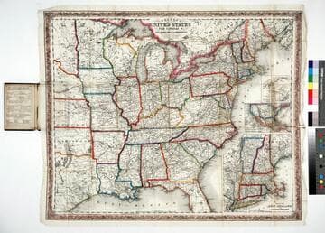
The traveller's guide or the map of the roads, canals & rail roads of the United States with the distances from place to place by H.S. Tanner
Visual Materials
Image of a map of the Eastern United States showing roads, canals, and railroads with eleven inset maps of the environs of Albany, Saratoga, &c., the Falls of Niagara &c, Quebec, Providence, Boston, Richmond, New York, Charleston, Baltimore and Washington, Washington, D.C., and Philadelphia; with references for Washington D.C. numbered 1-10 and references for Philadelphia numbered 1-6 and a-p.
priJLC_TRAN_001189
Colton's map of the United States, the Canadas &c showing the rail roads, canals & stage roads with distances from place to place
Rare Books
Kirkpatrick Catalogue entry: "2463 Colton, J. H., publisher. Colton's map of the United States, the Canadas &c. showing the rail roads, canals, & stage roads ... New York, J. H. Colton, 1860. 1 sheet. [see p.]."Alternate title from cover. Submaps: Map of New England and Eastern New York; Map of the United States & Central America; The Isthmus of Panama showing the Routes of Travel between Aspinwall & Panama. . Prime meridian: GM, Washington. Relief: hachures. Graphic Scale: Miles. Projection: Polyconic. Printing Process: Lithography. Other Features: Sub-maps. Verso Text: MS note: R.B. 11486, i Stamp: Kensington Public Libraries.
623637
Image not available
Mitchell's new traveller's guide through the United States : showing the rail roads, canals, stage roads &c. with distances from place to place / drawn and engraved by Ira S. Drake
Rare Books
For earlier editions of this map, see 224605, 82384, 82385, & 429902. Submaps: Map of the Copper Mine Region; Map of New England or Eastern States; Map of Gold and Quicksilver District of California; Map of Maritime and Overland Routes to California. Prime meridian: Washington. Relief: no. Graphic Scale: Miles. Projection: Polyconic. Printing Process: Lithography. Verso Text: MS note: Mr. Charles E. Tufts Book, presented to him by Robert H. Anderson, in the year of one thousand eight hundred and sixty at Cedar Point in Googhland County - Virginia.
442783
Image not available
Cary's new map of Ireland : exhibiting the whole of the turnpike roads with the rivers and canals ; the market and borough towns and principal places adjoining the road to which is added the distances from one market town to another as well as from the metropolis
Rare Books
Alte title from cover; sales sticker on cover reads: "Sold by C. Smith. Mapseller, 172 Strand, London." Prime meridian: GM. Relief: hachures. Graphic Scale: Miles. Projection: Cylindrical. Printing Process: Copper engraving.
386441