Rare Books
A geographical and historical description of the principal objects of the present war in the West-Indies. ... The whole compiled from the most authentic memoirs, ... To which is prefix'd an accurate map of the West-Indies
Image not available
You might also be interested in
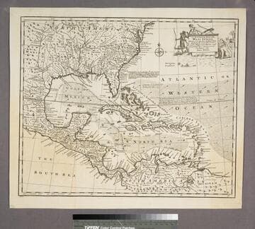
An Accurate Map of the West Indies
Visual Materials
Kashnor notes, "Includes Florida, Georgia, Carolina, Virginia, and Maryland. Also shows the coast of New Leon and present-day Texas." Kashnor dates as ca. 1767. RLIN record suggests 1747. Cartouche: Natives & Lion.. "Drawn from the best Authorities, assisted by the most approved Modern Maps and Charts, and regulated by Astronomical Observations. By Eman. Bowen." Prime meridian: London. Relief: pictorial. Graphic Scale: Miles. Projection: Azimuthal. Printing Process: Copper engraving. Other Features: Cartouche. Verso Text: MS note:943.
105:943 S

An Accurate Map of the West Indies, from the Latest Improvements
Visual Materials
Kashnor notes, "Shows the eastern coast from Cape Carteret to the mouth of the Orinoco, and locates New Leon in the position of present-day Texas." Kashnor dates as ca. 1760. MS note: 794 (on backing). Prime meridian: London. Relief: no. Projection: Pseudocylindrical. Printing Process: Copper engraving.
105:794 S
Image not available
A new gazetteer, or, Geographical dictionary. Of North America and the West Indies
Rare Books
339678
Image not available
A new gazetteer, or, Geographical dictionary. Of North America and the West Indies
Rare Books
376497
Image not available
North America and the West Indies: a New Map, wherein the British Empire and its limits, according to the difinitive(sic) Treaty of Peace in 1763, are accurately described, and the Dominions possessed by the Spaniards, the French and other European States; the whole compiled from the New Surveys and Authentic Memoirs that have hitherto appeared
Visual Materials
Kashnor notes, "Shows a good map of the Illinois and Ohio country. locating Chicago. The southern boundary of the Hudson's Bay Company territories is along latitude 49, running beyond the Lake of the Woods. In the map are also located the various H. B. Co. forts and factories." Kashnor dates as ca. 1763. Submaps and treaty articles. See 105:669 for another copy. RLIN record suggests 1764 date. Cartouche with Natives. Submaps: Particular Map of Baffin and Hudson's Bay; Map of the Country between Montreal, Albany and Oswego. . Prime meridian: London, Ferro. Relief: pictorial. Graphic Scale: Miles, Leagues. Projection: Pseudocylindrical. Printing Process: Copper engraving. Other Features: CartoucheSub-mapsFigures . Verso Text: MS notes: 532 Map c.1783.
093:532 M
Image not available
A description of the Spanish islands and settlements on the coast of the West Indies, : compiled from authentic memoirs, revised by gentlemen who have resided many years in the Spanish settlements; and illustrated with thirty-two maps and plans, ... and engraved by Thomas Jefferys
Rare Books
23127