Rare Books
A view of the coasts, countries and islands within the limits of the South-Sea-Company. : ... The whole collected from the best authors, as well manuscripts as printed. Illustrated with a general map, and particular draughts of the most important places; by Herman Moll, geographer
Image not available
You might also be interested in
Image not available
Scotland delineated;, or thirty six new and correct maps of North Britain, distinctly shewing the cities, towns, coasts, firths, and islands thereof; carefully composed and laid down by Herman Moll, ... and John Adair, late geographer of Scotland, ... Viz. I. Scotia antiqua ... 36. The Isle of Ila, &c
Rare Books
378322
Image not available
New & Exact Map of the Coast, Countries and Islands within the Limits of the South Sea Company from the River Aranoca to Terra del Fuego, and from thence through the South Sea, to the North Part of California &c. With a View of the General and Coasting Trade-Winds. And particular Draughts of the most important Bays, Ports. &ce. According to the Newest Observations, By Herman Moll Geographer
Visual Materials
Kashnor notes, "This is one of the earliest English maps to locate Mount Nevada in California, where are also located New Albion, Monterey, Port Sir Francis Drake, Mount St. Martin." Moll rails against French mapmakers at the bottom of this map. Note detailed map of Pepy's Island (nonexistent.) McLaughlin dates as [1711], notes this map as State 2 and gives appeared in information. Twelve submaps. Isle Chiloe, Bay of Guiaquil, Port of Baldivia, Chart from England to the Ananoca, Peypes or Pepys Island, Straits of Magellan, Isthmus of Darien, Gallapagos Islands, Juan Fernandez Island, Gulf of Nicoya, Gulf of Ampalla, Port of Acapulco.. Prime meridian: London. Relief: pictorial. Projection: Mercator. Printing Process: Copper engraving. Other Features: Sub-maps. References: McLaughlin 181; Phillips 554; Wagner 498.. Verso Text: MS note: 192..
093:192 M
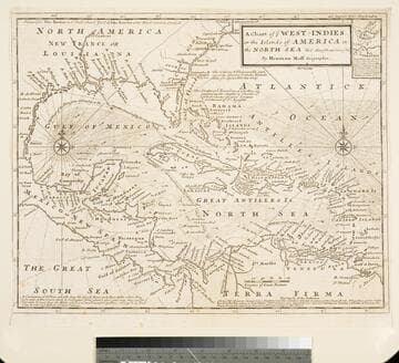
Chart of the West Indies or the Islands of America in the North Sea &c. Being the Present Seat of War. by Herman Moll Geographer
Visual Materials
Kashnor notes, "Shows the mainland around the Gulf of Mexico, with Louisiana, Florida, Georgia, and Carolina." Kashnor dates as ca. 1719. Submap: Vera Cruz harbor. Sailing instructions for galleons. MS note: 321 (on backing). Prime meridian: London. Relief: no. Projection: Cylindrical. Watermark: Two devices. Printing Process: Copper engraving. Other Features: Sub-maps.
105:321 S